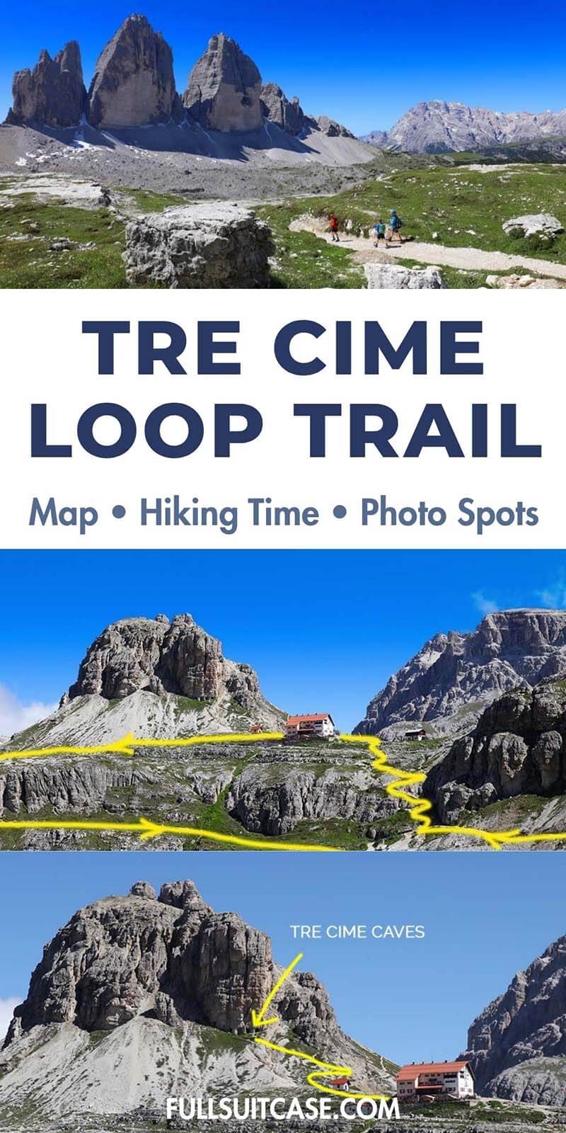
Tre Cime di Lavaredo Hike: Best Loop Trail, Map & Insider Tips
This site contains affiliate links, which means that we may earn a small commission, at no cost to you, for qualifying purchases. It supports the work that goes into keeping this content free. Thanks for reading! More info: Privacy Policy.
Planning the Tre Cime di Lavaredo hike and wondering what to expect? In this guide, you’ll find everything you need to know, including the best loop trail, a detailed map, hiking time, distance, difficulty, elevation gain, parking reservations, and the best viewpoints and photo spots along the way.
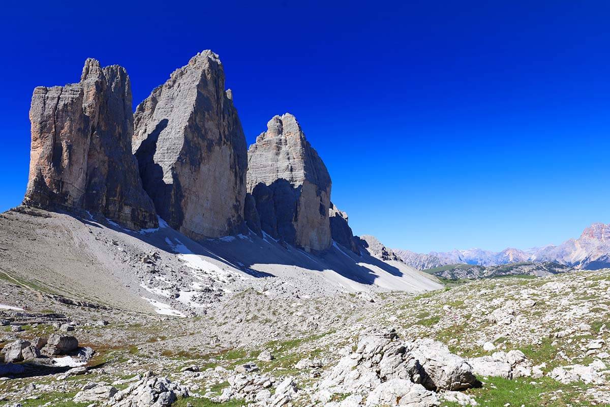
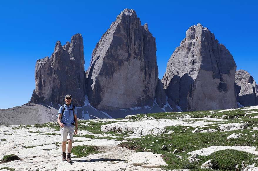
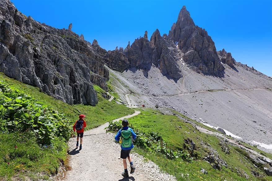
Tre Cime di Lavaredo (Drei Zinnen) is the symbol of the Italian Dolomites UNESCO World Heritage Site and probably the most iconic hike in the Dolomites. It seems that if people do just one hike in the Dolomites, they always choose this one. And quite rightly so – the views here are phenomenal!
We hiked the Tre Cime di Lavaredo loop trail twice, with kids, and in very different circumstances. So all the tips in this article are based on our first-hand experience, plus additional research that helped us discover a few amazing viewpoints and short detours that most other guides don’t mention.
Good to know: This guide covers every part of the hike in detail, from where to start and which direction to walk to the best photo stops, practical hiking tips, and how to plan your visit.
READ ALSO: Best Hikes in the Dolomites
Tre Cime di Lavaredo Hike Overview
- Distance: +-10 km / 6 miles.
- Difficulty: Moderate.
- Duration: 3-3.5 hours hiking time (allow 4-5 hours including photo stops).
- Elevation change: 340-400 meters (1,100 – 1,300 ft).
- Trailhead: Loop hike starting/ending at Rifugio Auronzo.
- Season: mid-June to mid-September.
- Practical tips (parking reservations, what to pack, and more).
Overview of the Tre Cime di Lavaredo hike:
- Start at Rifugio Auronzo (2.320 m).
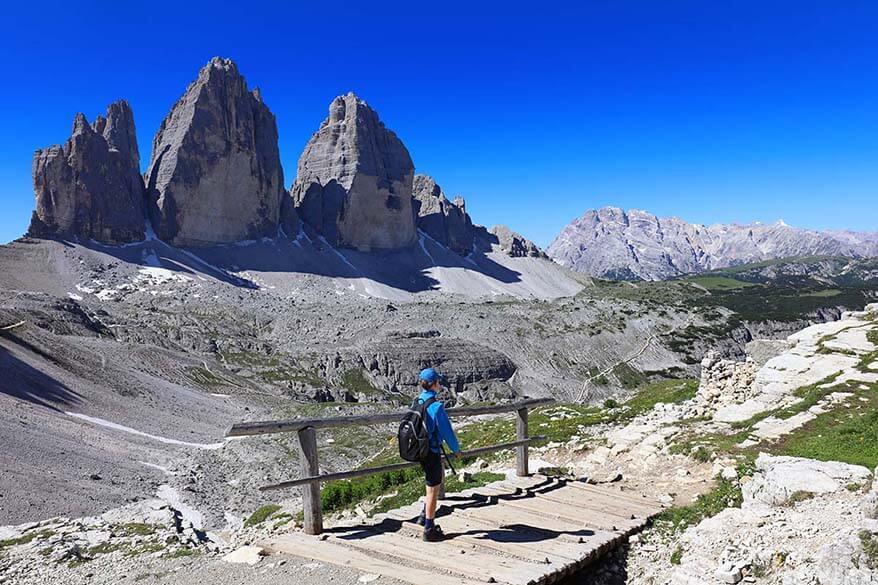
- Hike to Rifugio Lavaredo (2.344 m) and to Forcella Lavaredo (2.454 m).
- Continue in the direction of Rifugio A. Locatelli (2.405 m) and make sure to actually go up to the hut for amazing views (+ a secret photo spot from the nearby caves!).
- Afterwards, continue to Malga Langalm (2.232 m) and via Forcella del Col de Mezzo (2.254 m) back to Rifugio Auronzo (2.320 m).
Good to know: Based on the numbers above, it might look as if there is hardly any altitude change on the Tre Cime hike. However, it is an uphill/ downhill hike so there is some climbing to do. Depending on where exactly you hike, the total elevation gain of the Tre Cime loop is about 340 – 400 meters (over 1,000 ft).
Tre Cime di Lavaredo FAQ
Tre Cime di Lavaredo hike is about 10 km (6 miles). In addition, there are a few very nice short detours. We hiked about 11 km (6.8 miles) in total. Hiking the entire Tre Cime circular trail takes about 3 – 3,5 hours. This is walking time only. Realistically, you should count 3,5 to 5 hours for this hike.
Tre Cime di Lavaredo hike is a circular trail that starts and ends at the large car parking area at Rifugio Auronzo (see map below).
Tre Cime hike is a moderate hike with a total elevation change of about 340-400 meters (1.100 – 1.300 ft). Some parts of the trail are very easy and flat, whereas some others require a bit of uphill walking and are more challenging. That being said, you can do this hike even with kids.
Yes. You don’t have to hike the entire loop to enjoy the scenery. Many visitors simply walk to Rifugio Lavaredo or continue to Forcella Lavaredo for the classic views of the Three Peaks before returning the same way. If you have more time, you can continue to Rifugio Locatelli, visit the nearby lakes, and then head back the same way.
Tre Cime hike passes several mountain huts with restaurants and bathroom facilities. So yes, there are plenty of facilities along the Tre Cime di Lavaredo trail.
Tre Cime is the most popular hike and, in order to limit traffic, there are frequent buses between Cortina d’Ampezzo via Misurina to Rifugio Auronzo where Tre Cime hike starts. Buses only run in high season. More info at the bottom of the article.
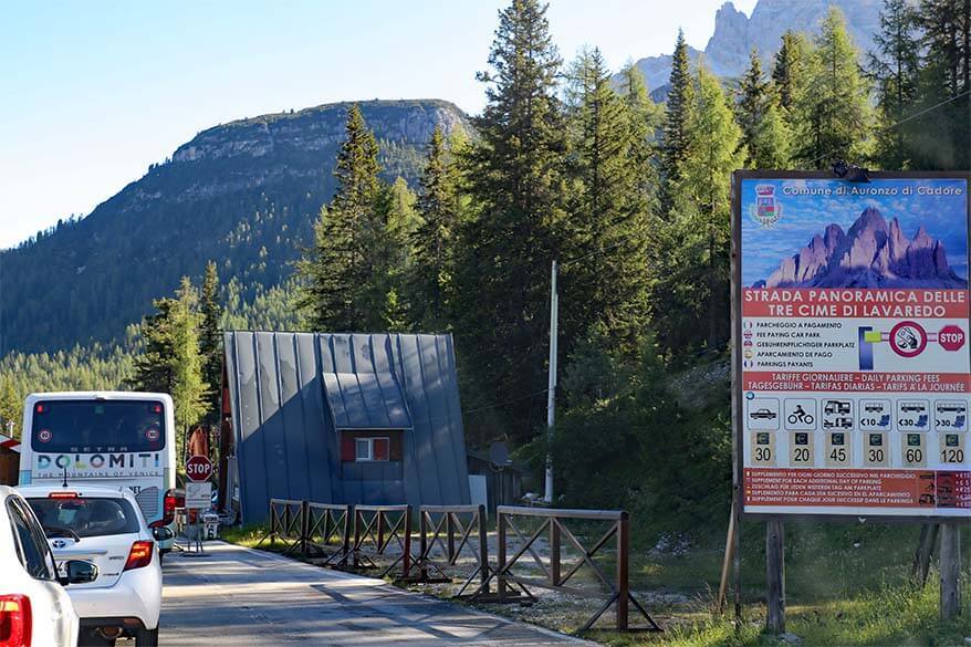
There is no fee to hike at Tre Cime. However, if you are driving to Rifugio Auronzo, you have to pay the toll fee for the scenic road. During the summer season, online reservations are required to drive up, so be sure to book your parking spot in advance.
Hiking season at Tre Cime di Lavaredo is between June and September. In June, there might still be quite some snow on the trail. Therefore, the very best time for the Tre Cime di Lavaredo hike is between July and the beginning of September.
Tre Cime Loop Trail Map
To help you get a better idea of where exactly to hike, I created a map indicating the exact Tre Cime di Lavaredo hiking route as described in this article.
Make sure to also read our explanation below so that you don’t miss the best views! The short detours indicated in purple, red, and yellow are well worth it if you want to experience the best views of the area.
How to use this map: Use your computer mouse (or fingers) to zoom in or out. Click on the icons to get more information about each place. Click the arrow on the top left corner for the index. Click the star next to the map’s title to add it to your Google Maps account. To view the saved map on your smartphone or PC, open Google Maps, click the menu and go to ‘Your Places’/’Maps’. If you want to print the map or see it in a bigger window, click on ‘View larger map’ in the top right corner.
What to Expect
When visiting Tre Cime, expect phenomenal scenery and lots of people. This is one of the top places in the Dolomites!
Tre Cime di Lavaredo hike is so popular because the three iconic mountain peaks are considered the symbol of the Dolomites. In addition to these impressive rocks, you can also enjoy some of the best far views in the Dolomites from this hike. Furthermore, this hike offers more variety than it looks at first sight. This area is stunning and well worth a visit!
The good news is that you don’t have to hike the entire loop around the Tre Cime peaks in order to enjoy the views. You can just hike to Rifugio Lavaredo or to Forcella Lavaredo and be rewarded with the most spectacular scenery. The negative side is the crowds. Tre Cime is a popular place with locals, international visitors, and also big bus tours. If you can, try to avoid coming here on weekends!
Good to know: If you are prepared to hike the entire loop, you’ll be glad to know that most visitors don’t go further than Forcella Lavaredo. So while the first part of the hike is really busy, it gets quieter after that.
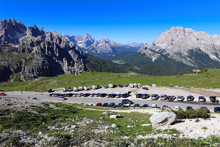
TIP: If traveling in high season (July or August), try to arrive at the Tre Cime car parking before 8 – 8.30 AM. It gets really busy here and even though the parking area is huge, it can fill up early. It’s even worse on the weekends… Or – weather permitting – come later in the afternoon, when people are starting to leave.
Hiking Tre Cime di Lavaredo Loop – Trail Description & Photos
Below, you can find detailed instructions for separate sections of the entire Tre Cime hike. I also included a few small detours that we highly recommend. Take a look!
Tre Cime Loop Trailhead
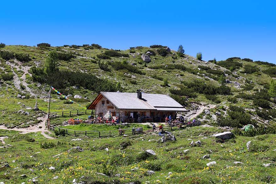
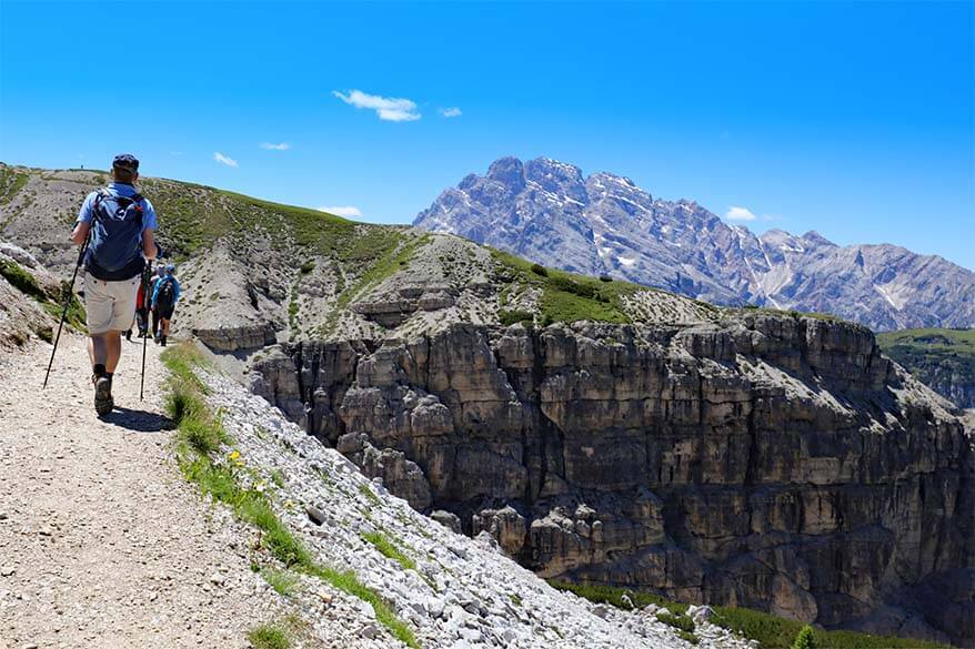
Tre Cime di Lavaredo loop trail starts at Rifugio Auronzo.There is a huge car parking area here, over several levels, and it might look overwhelming to find the start of the hike when you arrive.
The Tre Cime hike starts right behind Rifugio Auronzo, on the left back side of the restaurant. If you are parked on one of the upper parking areas, just walk to the east and you can join the wide gravel path above Rifugio Auronzo, without necessarily having to walk down to the mountain hut first.
We recommend hiking Tre Cime loop anticlockwise. But if you want to go in the opposite direction, you can find the trailhead on the western side of the upper parking area.
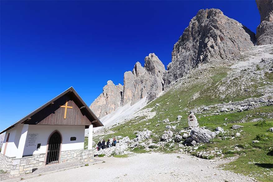
Rifugio Auronzo to Rifugio Lavaredo
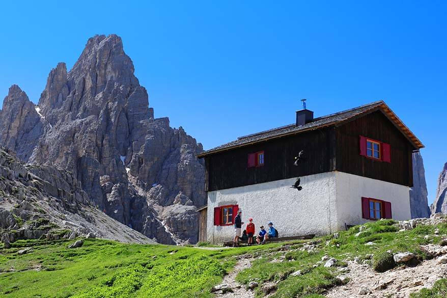
Once you find the wide gravel road behind Rifugio Auronzo, just walk east in the direction of Rifugio Lavaredo. About halfway, you’ll see a small chapel, Cappella degli Alpini.
Don’t forget to stop once in a while and also look at the view behind you. The scenery in the other direction is spectacular so don’t miss it!
The first part of the hike is flat and very easy. This is also by far the busiest section of the entire trail. You’ll see families with young kids (the path is accessible for strollers) and groups of tourists walking here. Rifugio Auronzo – Rifugio Lavaredo walk is 1.7km one way and takes about 30 minutes.
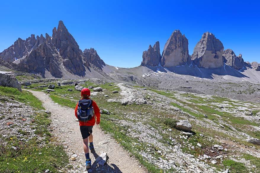
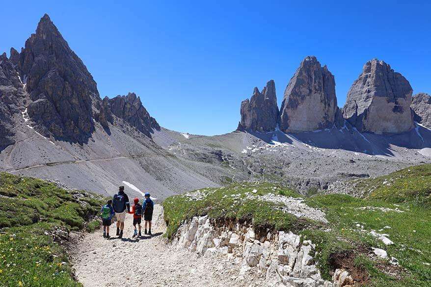
Rifugio Lavaredo to Forcella Lavaredo
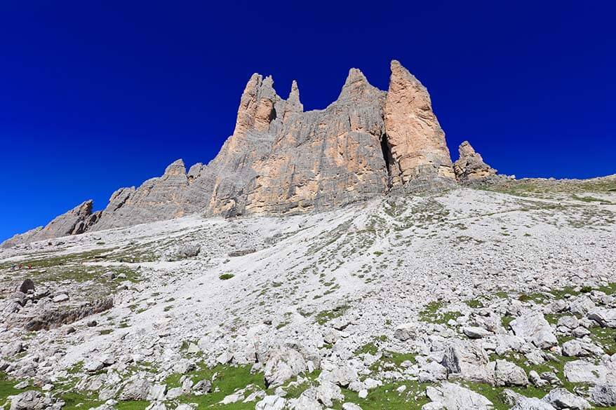
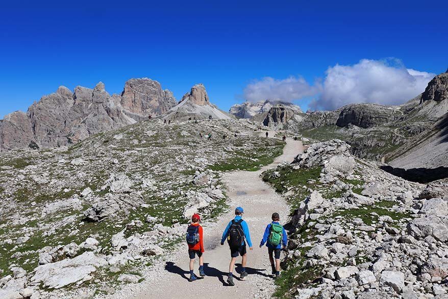
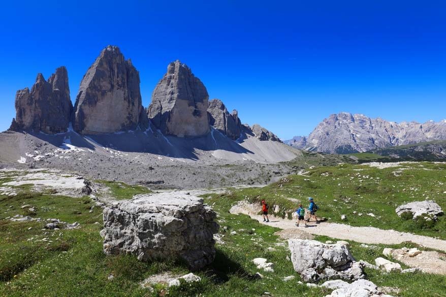
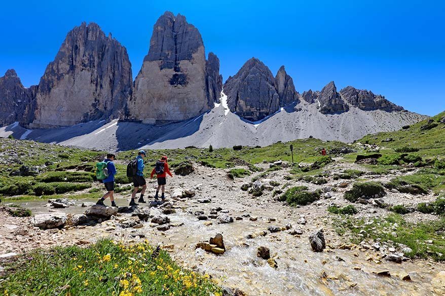
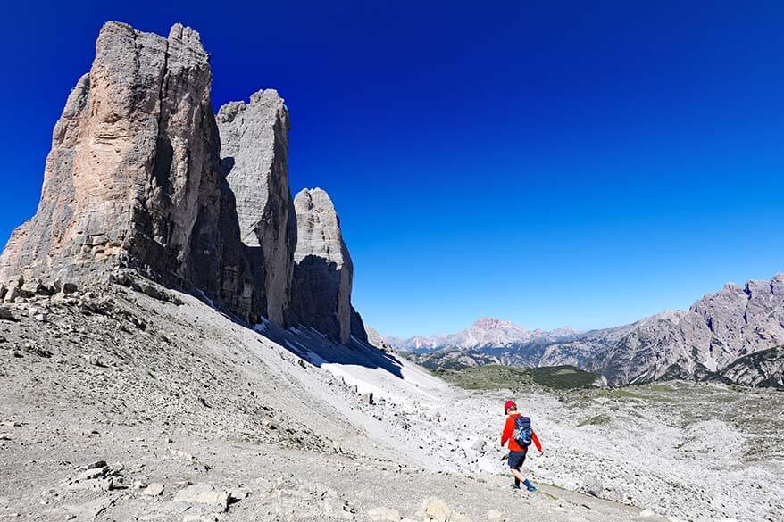
At Rifugio Lavaredo, you have 2 options (!) on how to reach Forcella Lavaredo (Patternsatel). This is the first place from which you can see the famous Three Peaks of Lavaredo. Most visitors and especially tour groups don’t go further than this point.
The first trail to Forcella Lavaredo can be found just before you reach the Rifugio Lavaredo mountain hut. It’s a narrow path to the left, following the edge of the mountain and leading straight to the Forcella Lavaredo viewpoint. This trail is quite steep, but it’s also shorter. Count about 20 minutes to get here from Rifugio Lavaredo (+-1km).
Alternatively, you can also continue walking past Rifugio Lavaredo and follow the wide gravel road all the way to Forcella Lavaredo (I indicated this detour in purple on the map above). This trail is longer and will take you about 30 minutes, it’s a bit less steep than the first one.
We did both of these trails – one the first time we hiked Tre Cime and the other one – the second time. I find that the wide road that leads past Rifugio Lavaredo offers better views. You are walking a bit further away from the Tre Cime peaks and have a better overview of the area. It takes a bit longer, but I think it’s worth it.
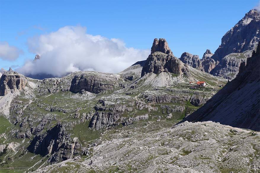
No matter which trail you take, it’s quite steep. However, you’ll quickly forget the tiring climb once you see the views at Forcella Lavaredo. On your left, you can see the famous three peaks Tre Cime. On the right side, in the distance, you can see your next destination, Rifugio Locatelli (Dreizinnenhütte).
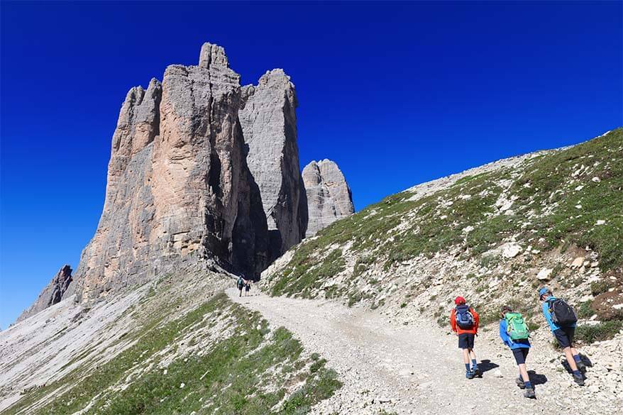
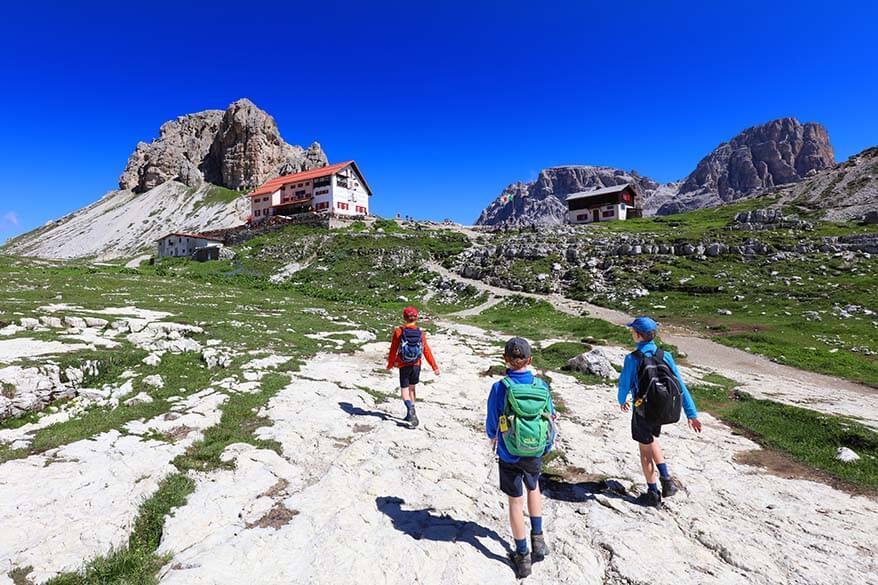
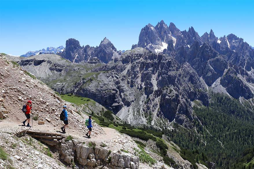
Forcella Lavaredo to Rifugio Locatelli
The trail from Forcella Lavaredo to Rifugio A. Locatelli (trail 101) is very easy. You follow a wide gravel road and go downhill most of the time. This is a road that is also used for supplies to the hut and a small truck passed us on this road. This part of the hike is about 2 km and will take approximately 40 minutes.
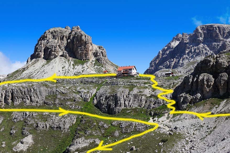
Please note that you do not have to go all the way to Rifugio Locatelli if you are just planning to hike the Tre Cime trail as it splits to the left just before the turn-off to the mountain hut (to the right). Because this mountain hut is located on the hill and requires a short climb, many people hiking Tre Cime loop don’t seem to take this detour. But you definitely should!
Good to know: Do not turn off to the left earlier; only once you reach the Rifugio Locatelli intersection. Otherwise, you’ll be hiking at the base of the Tre Cime peaks on a narrow stone track that’s not half as nice. You don’t really have to worry about doing this by coincidence though – the wide gravel road to Rifugio Locatelli is very clear, so just follow it to the hut.
This is about half-way through the Tre Cime loop. If you choose not to go up to Rifugio Locatelli, follow signs to Malga Langalm/ Lange Alm to your left (trail 105). If you hike fast, you can get back to the Rifugio Auronzo parking area in about 1.5 hours from here.
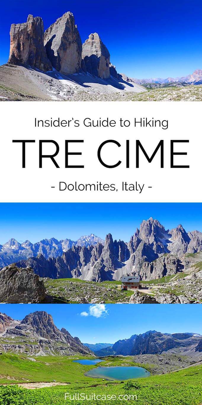
However, I recommend making a short detour to Rifugio Locatelli and see the beautiful lakes there – more info below. See also the picture with the suggested hiking route indicated in yellow.
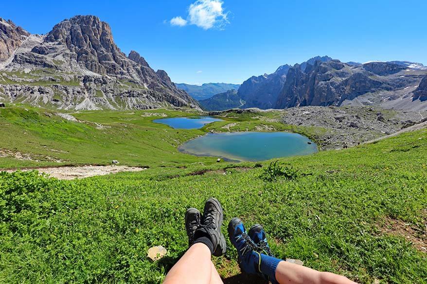
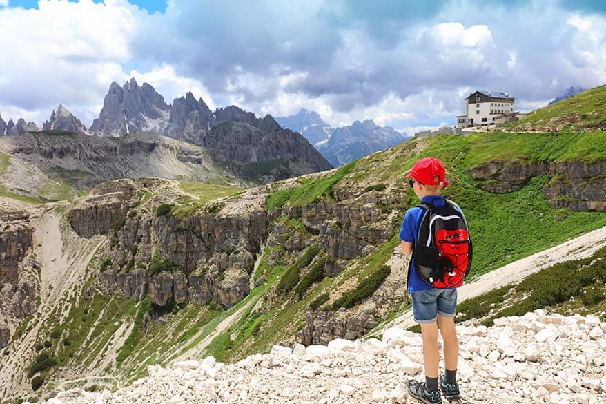
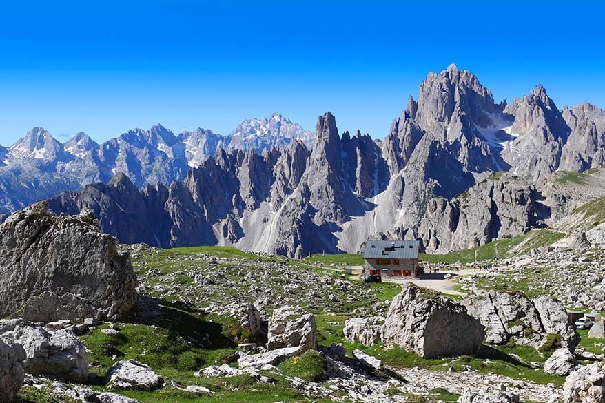
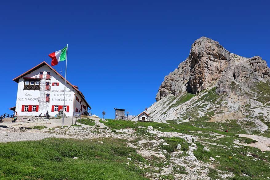
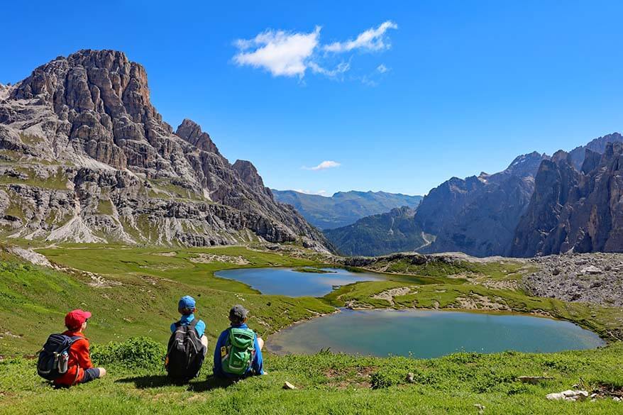
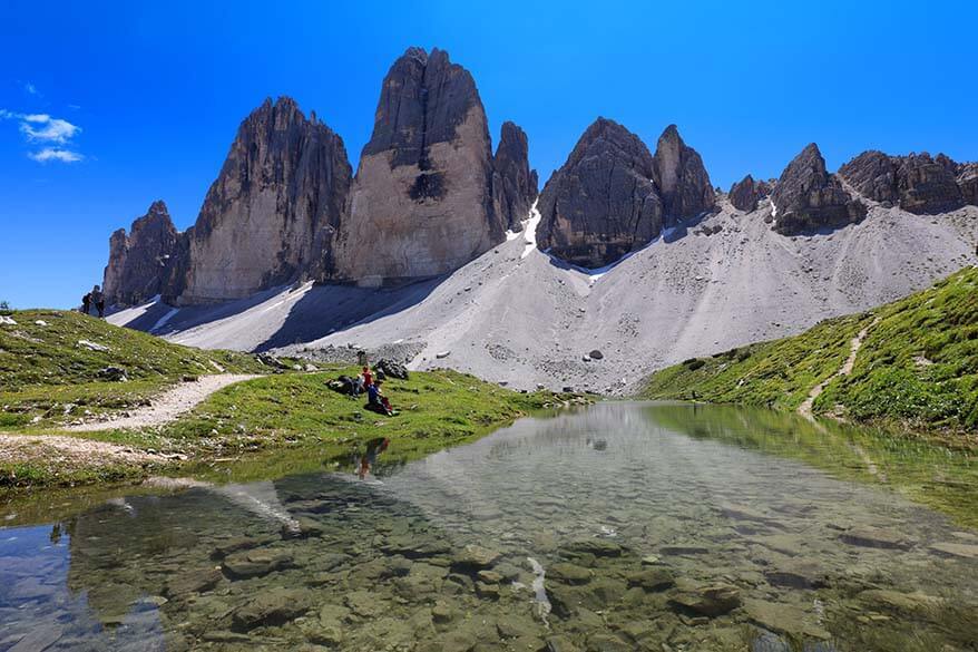
Rifugio Locatelli & Piani Lakes
A short detour to Rifugio Locatelli (indicated in yellow on the trail map at the top of this post) is well worth it because it will give you an opportunity to see a very picturesque scenery that you would completely miss otherwise.
However, I couldn’t find any information about this when I was doing research for our hike. It’s as if most people just hike the Tre Cime loop as quickly as possible to tick the box… Anyway, now that you are here and reading this, you know better than that!
Insider TIP: At the top of the hill, right behind a small hut next to Rifugio Locatelli, you can see two mountain lakes – Laghi dei Piani – in the most beautiful setting. This is one of the very best viewpoints of this area and it’s definitely worth a short climb of 5-10 minutes.
This is also a great place for a picnic! Alternatively, you can have lunch or a drink at the restaurant of the Rifugio Locatelli.
If you have more time and energy, you can also walk down to the lakes or even make a longer detour and explore the area further. There’s one more small lake in this area, but it would require at least a 15-20 minutes hike one way and I’m not really sure if it’s worth it.
Good to know: After visiting the lakes at Rifugio Locatelli, do not take the same steep path down again, but continue walking behind the Rifugio Locatelli and past a small chapel Chiesetta Alpina. There is a wide gravel road here that goes a bit downhill. It will soon turn back in the direction of the three peaks, offering yet another stunning angle of these iconic mountains.
This track will bring you to the same intersection where you turned off to Rifugio Locatelli. From there, you join the narrow alpine trail in the direction of Malga Langalm (trail 105), just as you would have done without this detour.
Unless, you first want to take a detour to one of the most scenic photo spots at Tre Cime – see below!
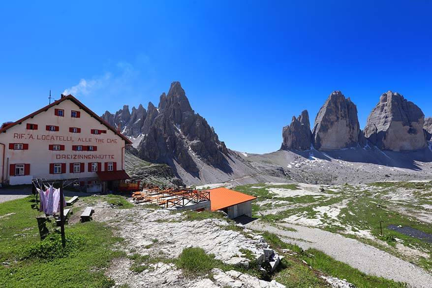
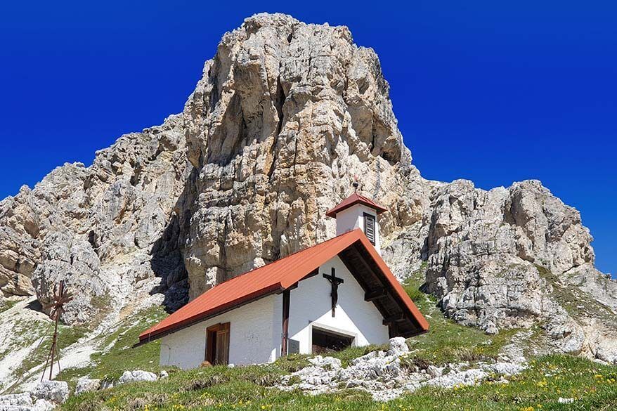
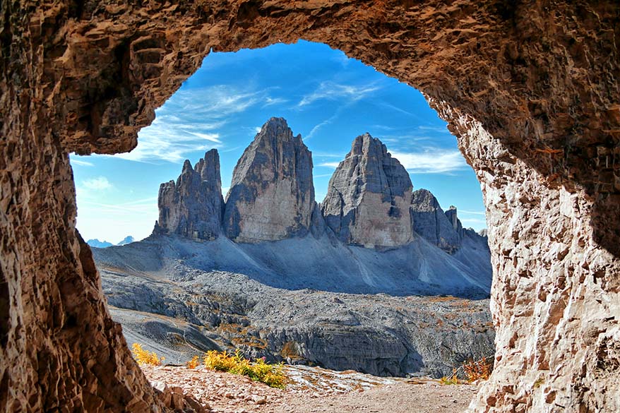
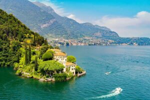
Photo detour to the caves overlooking Tre Cime Peaks
You may have seen pictures of Tre Cime taken from a unique perspective from inside the caves. Nowadays, this has become one of the most photographed viewpoints at Tre Cime.
If you don’t mind a short extra hike, you can easily visit several caves from Rifugio Locatelli in about 10-15 minutes. They are located a bit uphill behind the hut and can be reached following the signs in the direction of ‘Via Ferrata Torre di Toblin’.
There are several caves here, each offering a bit different perspective and frame for your photos.
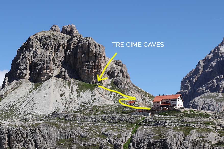
Next, head back down to Rifugio Locatelli and continue further following the Tre Cime loop trail.
TIP: As you walk down from Rifugio Locatelli and before joining trail 105 to Malga Alm, you’ll pass an intersection of trail 105 with arrows pointing in the direction of Rifugio Tre Scarperi (Dreischusterhütte).
I recommend turning off to the right and walking just 100-200 meters along this path (indicated in red on our map). The views here are absolutely worth a few minutes of your time! After that, turn around and get back to your original trail in the direction of Tre Cime.


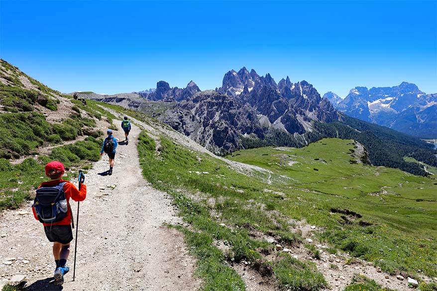
Rifugio Locatelli – Malga Langalm
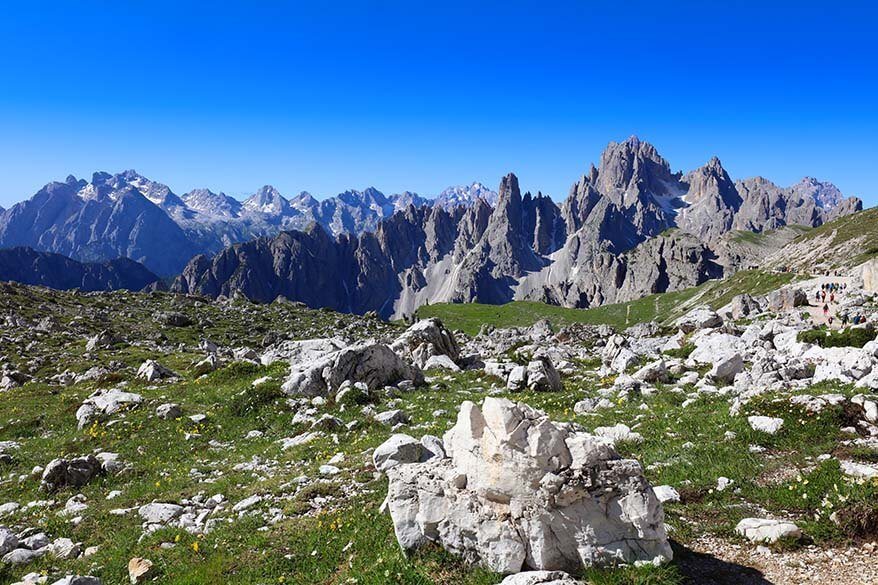
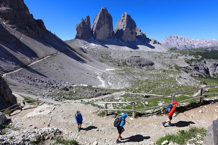
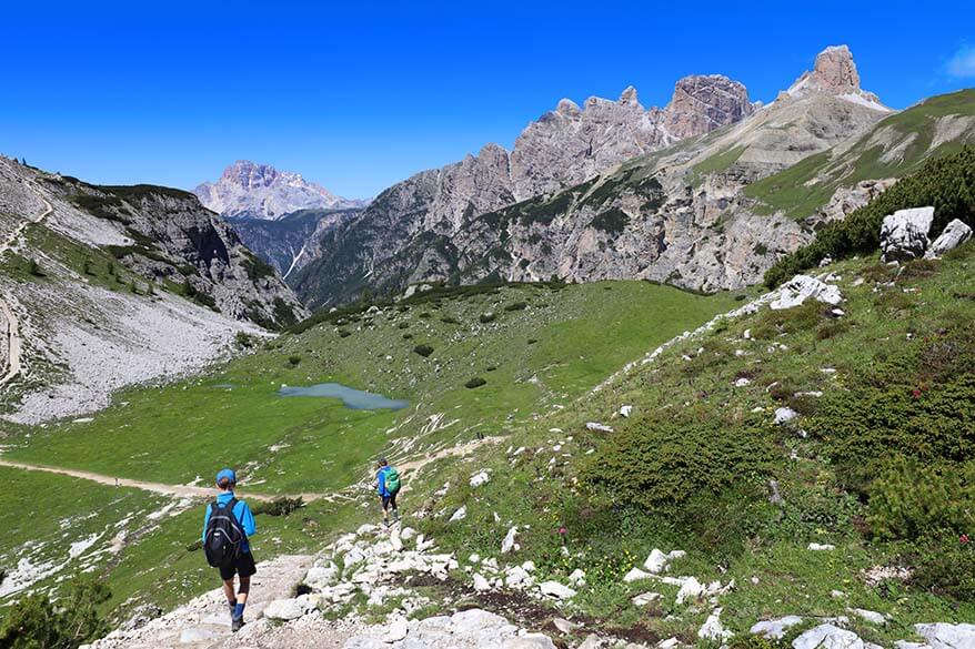
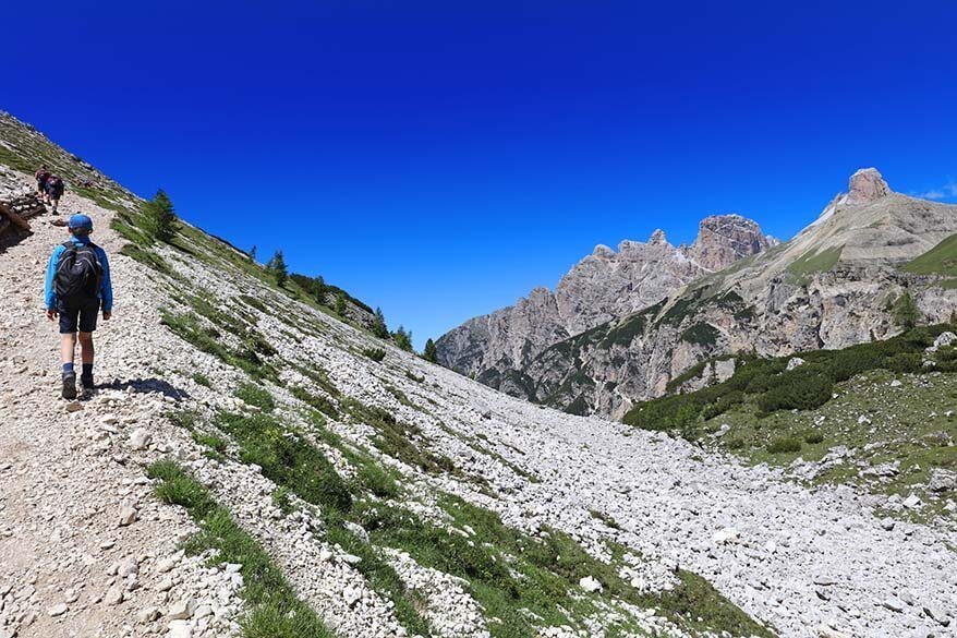
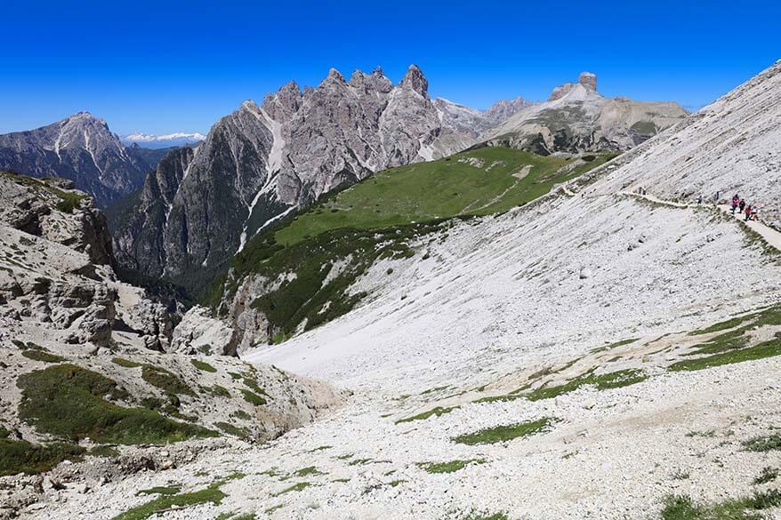
The 40-minute hike from Rifugio Locatelli to Malga Langalm mountain hut is probably the most challenging part of the Tre Cime hike. It’s not a difficult trail, but it does go down quite a bit, which means that you have to climb back up after that. If you have hiking poles, you may want to use them here, especially if it’s wet.
Luckily, this is a very beautiful part of the hike as well. At first, you walk in the direction of the Tre Cime peaks and just can’t get enough of those views. Once you descend down into the valley, the three peaks disappear, but you’ll find stunning alpine scenery and green lush meadows with an incredible variety of mountain flowers.
As you hike uphill again, the absolute-best views are on your right side. Take a moment to stop and enjoy the stunning scenery and the incredible colors of the mountain formations in the distance.
Once at the top of the hill, the three peaks of Tre Cime emerge again. This is such a beautiful area with the very best views of Tre Cime di Lavaredo and endless fields of wildflowers…
Shortly, you’ll see a small wooden chalet in the distance. That’s Malga Langalm, your next point of reference along this hike. By this point, you have hiked about three-quarters of the Tre Cime loop.
Malga Langalm – Forcella del Col di Mezzo
Malga Langalm is a small mountain hut with a restaurant. This is your last chance to get some apple strudel or Kaiserschmarrn before heading back to Rifugio Auronzo (40 minutes) where you left your car.
Even now, when your hike around Tre Cime is almost over, there are still several surprises along this beautiful trail. So don’t rush back to the car just yet!
This part of the Tre Cime loop has the greenest landscapes. Mountain streams, lakes, flowers – it’s really pretty.
TIP: Soon after you pass Malga Langalm, you’ll see a mountain river on your left side. Just a bit further, you’ll be walking next to a small lake (there are actually three small lakes here). If you have a few minutes to spare, take a short detour here as well and walk a bit to the left so that you get a better view of the lake.
If there is no wind and the water is still, you could be rewarded with some amazing reflections of Tre Cime peaks here. But even if there are no reflections (as in our case), this is still a very nice place to linger a bit longer.
The last part of the trail just before Forcella del Col di Mezzo is probably the most ‘dangerous’ section of the entire loop. It follows the rocky mountain edge and the path is quite narrow. So if you are hiking with younger kids, you may want to hold on to their hands here.
The views are stunning, however, but you better stop to admire them because this is really not a place you want to misstep off the trail by accident.
Forcella del Col de Mezzo – Rifugio Auronzo
The very last part of the hiking trail is also extremely picturesque. After you reach Forcella del Col de Mezzo, the track gets somewhat wider. From here, you can see Lake Misurina and its historic hotel far in the distance.
The views remain spectacular until the very last moment. Even back at the parking lot, the scenery is absolutely stunning.
That’s the beauty of the Tre Cime loop trail – it’s incredibly diverse and extremely rewarding. Every single part of this hike is worth it in itself. But add them all together and you’ll understand why this iconic hike is so popular.
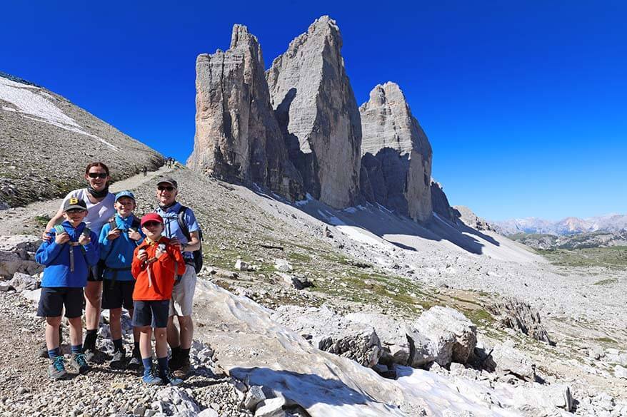
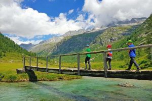
Hiking Tre Cime di Lavaredo Loop with Kids
Tre Cime hike is a very popular hike, also for families. We hiked this trail with our kids and we saw lots of other people hiking here with children. That being said, it’s quite a long hike that requires some uphill climbing, so keep that in mind when planning to hike Tre Cime with kids.
I think that school-aged kids who are somewhat used to hiking could probably complete this trail without too many issues. I’d be reluctant to do the entire loop with kids younger than 6, but it depends on what your child is used to, how many you kids you have, whether you are prepared to carry them if needed, etc.
TIP: If you have younger kids, you could just hike to Forcella Lavaredo or maybe even to Rifugio Locatelli and the lakes and then back.
Our experience: We did the entire loop with our three kids age 9, 9, and 11 and could hardly keep up with them. Two years earlier, we hiked part of this trail when the kids were 7, 7, and 9 and they also managed just fine. At that time, we couldn’t complete the trail because of the weather and not because of the kids…
Getting to Tre Cime di Lavaredo
Tre Cime di Lavaredo hike trailhead – Rifugio Auronzo – can be reached by car or public transport.
By Bus
If you are staying in Cortina d’Ampezzo or in Misurina, you can also take a bus to Tre Cime. This would save you high parking fees and you don’t have to worry about finding a parking spot. However, as we learned, the bus schedules in Italy aren’t always reliable, so make sure to check in advance if the bus operates on the day of your visit.
Buses only run in high season. You can find more up-to-date information for the Tre Cime bus on the Dolomiti Bus website.
By Car
If you are driving, you’ll need to get to Misurina first. From there, it’s a 7.5 km (15 min) drive to Rifugio Auronzo.
TIP: During the summer season, access to Rifugio Auronzo by car requires an online reservation in advance. If you don’t have a reservation, you’ll need to use public transportation instead.
If coming to Misurina from the south along road SP49, take the first turn to the right after you pass Misurina Lake. So not the parking area at the north side of the lake, but the road a few hundred meters further north. Tre Cime is clearly indicated here.
If coming from the north, you’ll have to turn left just before you reach Misurina. If you are at the lake, you already drove too far. Once again, Tre Cime is clearly signposted.
Once you are on this road (see map), you’ll first reach the toll booth, where your reservation is checked and you pay the road toll (if not paid in advance). Afterward, you drive all the way up Strada Panoramica delle Tre Cime di Lavaredo until you reach a huge parking area near Rifugio Auronzo.
Alternatively, you can leave your car at the parking area a bit lower down the road, just before Lago d’Antorno. There is a bus stop by the lake and you could take a bus from there.
Practical Tips for Visiting Tre Cime di Lavaredo
- Check the weather forecast and don’t attempt this hike if there’s a chance of lightning! This area is well above the treeline. The first time we hiked here, we had to run back for shelter because of lightning and heavy rain.
- Arrive early in the morning and avoid summer weekends. To give you an idea, last time we visited, we were here on a Tuesday in the first week of July and the giant parking area was almost full at 8.45 AM.
- Reserve your parking as soon as your travel dates are confirmed, especially if visiting in July or August. See here for more info.
- If the weather forecast is extremely good and you are sure there will be no afternoon storm, you could also opt to come here in the afternoon and start your hike later. That way you could avoid the biggest crowds.
- The best time to hike Tre Cime is at the end of August – beginning of September, on a sunny weekday. But any time in the summer is good, just try to avoid weekends and start early.
- Wear good hiking shoes. We now always hike in our Lowa Renegade GTX hiking boots, but if the trail is dry, light hiking shoes like this should be sufficient. Don’t attempt this hike in sneakers. We also always pack good trekking poles; they make the downhill sections much easier on the knees.
- Always carry a sweater and a rain jacket with you. It can be very windy and cold here, about 10°C colder than in the lower areas nearby. We started our hike with sweaters and jackets and were hiking in t-shirts for the biggest part of the day. Kids wore their sweaters almost the entire time and this was on a very warm sunny day in July. We also always pack a rain cover for our backpacks. After a few unexpected downpours over the years, we never hike without a rain cover.
- Sun protection is a must in summer as there is hardly any shade on this trail. We always carry a good sunscreen spray on hikes like this.
- Pack enough drinking water. We always carry one refillable bottle per person (we like insulated water bottles like this). In addition, there are several restaurants along the way, so you can always get some food and drinks there too.
- Count at least 4 hours if you want to enjoy this hike rather than just rush from one point to another. We arrived at Tre Cime at 9 AM and were back in our car at 2 PM. So we spent 5 hours here in total (picnic and lots of photo/ rest stops included) and it felt like a very leisurely experience.
- Stay in Misurina if you want to start this hike as early as possible. There are several good hotels nearby. Albergo Chalet Lago Antorno, on the shores of the beautiful Lake Antorno, is the closest hotel to Tre Cime (apart from the mountain huts). You can find more accommodation options in Misurina here.
READ ALSO: Where to Stay in the Dolomites
So, this is our guide for hiking the famous Tre Cime di Lavaredo loop. I tried to cover all the details, but if I forgot something and you have any additional questions, feel free to leave a reply below and I’ll try to help. Enjoy your hike!
READ ALSO: Lago di Sorapis Hike (another must-do hike in the Dolomites!)
More travel inspiration for the Dolomites:
- Best Places to See in the Italian Dolomites
- Dolomites Itinerary (suggestions for any trip, from 1 to 10 days)
- Hiking in the Dolomites – Best Hikes
- Most Beautiful Lakes in the Dolomites
Detailed guides for visiting some of the best places in the Dolomites:
- Marmolada (the Queen of the Dolomites – the highest viewing platform, easy to get to by cable car)
- Cinque Torri (very nice easy hike near Cortina d’Ampezzo)
- Lago di Braies (the most beautiful lake in the Dolomites that you can easily visit)
- Lago di Dobbiaco (a nice alternative to Lago di Braies)
- Lago di Limides (picturesque mountain lake, easy hike)
- Lago Federa (requires a hike, the scenery if hiking from Passo Giau is amazing!)
- Where to Stay in Val Gardena
TIP: Save this guide for later, share it with your friends, or pin it to Pinterest so you can easily come back to it when planning your trip.
More travel inspiration for Northern Italy:
- Best Things to Do in Venice + Tips for Venice Gondola
- Venice in One Day (can be easily done as a day trip from the Dolomites, see also how to visit Venice by car)
- 3 Days in Venice
- Val di Fumo Hike (the pearl of the nearby Trentino region)
- Trentino with Kids (off-the-beaten-path, activity-filled trip)
- Lake Garda
- Best of Lake Como & Tips for Visiting Lake Como
- Best Things to Do in Milan
- One Day in Milan
- Best Things to Do in Verona
- Best Things to Do in Bologna
- Bellagio, Varenna, and Most Beautiful Towns in Lake Como
- Where to Stay at Lake Como
- Best Cities in Italy
- Best Places to See in Italy


We are planning a trip for this summer and your article is really helpful. We are essentially 4 adult – 2 adults and kids age 17 and 19. We can handle the hike, but really really don’t want to be in a large crowd. It sounds like your pictures are from July, are there really very few people after the first 2km? This looks like an amazing hike that would be worth doing but would prefer more solitude than July may offer. Thanks!
Hi RB, Tre Cime is one of the most popular hikes in the Dolomites, so the crowds are unavoidable. It gets a bit quieter after the first part, but you will never be alone on this hike.
If you want solitude, I highly recommend looking into other areas and lesser-known trails. Alternatively, start VERY early in the morning and visit on a weekday – it’s the only way to avoid the biggest crowds.
Hope this helps. Have a great trip!
Hello, you have prepared a great guide, thank you. On the map where you show the loop, you have marked the path behind the summit with a cross. Do you not recommend that route? Which route would you recommend from Forcella Laverado to Malga Langalm to shorten the road a bit? Or what would be your advice for those who can’t do it all the way? Thank you.
Hi Ozan, yes, indeed, I do not recommend that route. I think I explained why in the article. You would be hiking so close to the three peaks that you wouldn’t properly see them. Also, there are lots of stones and gravel there – not the nicest trail.
I recommend not shortening the route because you’ll miss the nicest views if you do. If you can’t do the entire hike, you could just walk to Forcella Lavaredo. Most people do this and then turn back. You can also walk a bit further to Rifugio Locatelli, have lunch there, and walk back the same way you came if you don’t feel like doing the entire loop.
Hope this helps. Have a great trip!
Great info! Thank you. How do you view the usefulness of hiking poles for middle age folks on this trip; and, I see many Tabacco Maps with “Dolomite” in name but which number map (if you know) covers your experience as you described it? Otherwise, great website!
Hi Greg, if you normally like to use trekking poles when hiking, I think you’ll be glad to have them with you in the Dolomites too. Otherwise, for most hikes, it’s not an absolute must.
As for the maps, this map (no. 03) covers the Cortina d’Ampezzo area and this hike should be just in there. You don’t absolutely need a map if you are just doing this hike as there are so many people and so many signs that it’s impossible to go wrong.
Hope this helps. Have a great trip!
@Jurga, Thank you for the tips, Jurga. Much appreciated!
Hi Jurga, truly appreciate the detailed information you have provided! It is greatly helpful!
You mentioned that hiking season begins in June. Do you know if it is still possible to get up to Rifugio Auronzo (by car) in late April to have a look at the view? Thanks for any pointers related to this.
Best regards,
Scott
Hi Scott, I highly doubt if the road toward Rifugio Auronzo will be open in late April already, but I don’t know for sure. There is often still snow on this hike in June, so the roads will probably be in a bad condition (closed?) until at least late May – June. But if you are in the area, you can always check. The winter has been very mild this year with little snow, so who knows.
Hi Jurga
You indicated the elevation gain is 400m. If I am hiking to Locatelli is that within that 400 m of gain?
Best Regards
Jerry
Hi Jerry, yes, in principle, this is the total elevation change you have on this hike. But it’s really not as straightforward as with many other hikes and you’ll be going up and down and up and down several times throughout this hike. It also depends on which trail you choose to follow – there are a few alternatives here and there, so use this just as an indication. It’s not a difficult hike, but it’s not a walk in the park either, so you have to be prepared to do some uphill walking.
Thank you for this article-very detailed and clear.
Can we do the whole loop with a toddler (2.5) in a back carrier? We want to do this hike in the end of September, with kids (2.5, 8,15). We did several long hikes in Pyrenees last year, managed ok.
Hi Anna, it really depends on you. If you can walk 3 hours with a kid of that age on your back, then I assume you could. I know I wouldn’t be able, but it’s just me. 🙂
You can also just do a part of the hike (maybe to the first viewpoint or to the mountain hut Rifugio Locatelli), see how it goes, and decide at that time how far you want to continue.
Thank you so much for this very detailed information about hiking the tre cime trail! It really helps to come across such great information!
I am supposed to to be there in the later part of September for a couple of days and I’m trying to figure out which day to try to do this particular trail. The last sun of September or the day following – the last Monday of September. I am mostly curious if any of the Rifugios will still be open and if the date/day of the week will make a difference. Do you have any advice on this?
Hi Nicki, if you can, just wait and see what the weather looks like before deciding. Tre Cime is really high in the mountains and ideally, you only go hiking there when the weather is really nice.
And if both days are just the same weather-wise, then Monday will likely be much less busy.
As for the refugios, I don’t know, but I’m sure you can contact them by phone/email if you absolutely need to know if and when they are open.
Many thanks for this detailed guide! I did a lot of research but nothing compared to this!
Wow! Glad to hear that, Fleur. Enjoy the hike!
Thank you so much for this extensive description, it really helped me plan our hike with my 9 month daughter, completed the whole round yesterday! It was absolutely beautiful!
Glad to help, Therese. Enjoy the rest of your time in the Dolomites!
Hi, we want to do a 3 day hike of the tre cime lavaredo track. I have managed to book one night stay over at the dreizinnen hut. Which other hut is recommened on this hike or is one night sufficient?
Thank you for your detailed information about the hike, you have done a great job!
Kind regards,
Ilona
Hi Ilona, there are lots of amazing huts in the Dolomites and lots of hikes that you can do, making them as long or as short as you want. For the Tre Cime hike as described here, you don’t have to stay overnight at all – the loop hike can easily be done in just a few hours.
But yes, there are plenty of trails in the area and you could make a longer trip out of it, but I can’t recommend anything since we haven’t done this ourselves.
My best suggestion would be to buy a Tabacco hiking map for the area where you are planning to hike and then research the different trails and the huts along the trails.
Or – if you are simply looking to do some nice hikes – take a look at our suggestions with some of the best short hikes in the Dolomites. None of them involve any overnight stays in the huts, but you can do that too if it’s the experience you are interested in.
Hope this helps a bit.
Greetings from Bulgaria! I came across your travelogue by chance, and liked it very much👍🏻. You give very good and inspiring information. I’m very glad to found your website!
Thank you for the kind feedback, Veselin. I hope that you come back to our website for more travel inspiration in the future as well!
Happy New Year and happy travels!