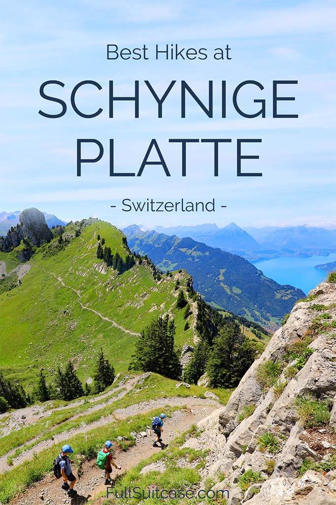
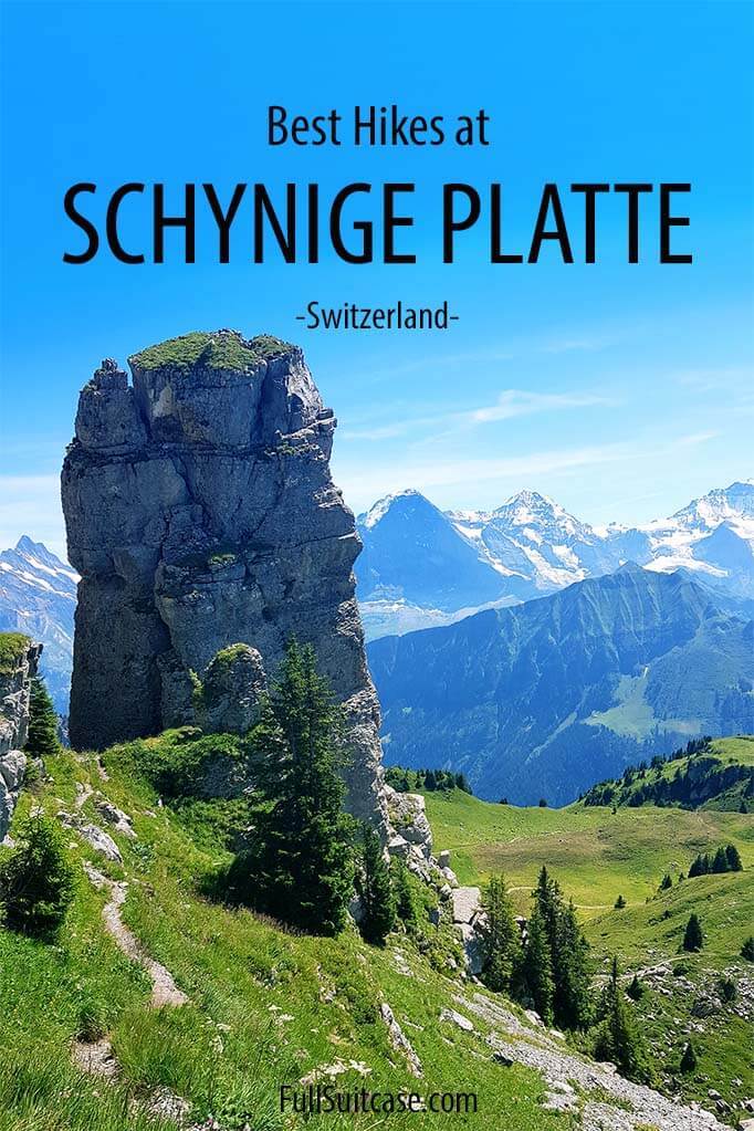
4 Best Hikes at Schynige Platte (+Map, Info & Tips)
This site contains affiliate links, which means that we may earn a small commission, at no cost to you, for qualifying purchases. It supports the work that goes into keeping this content free. Thanks for reading! More info: Privacy Policy.
Thinking of hiking at Schynige Platte in Switzerland, but not sure which hike has the best views or is the most suitable for you? In this guide, we highlight the 4 most popular Schynige Platte hikes: Daube viewpoint hike, Oberberghorn Panorama Trail, the extended version of this hike – Louchernhorn Panorama Trail, and also the most strenuous hike in the area – the Schynige Platte to First hike.
Read on to learn more about each of these hikes, which one to choose, and why!
Just for the sake of clarity, there are more hiking possibilities at Schynige Platte than mentioned here. You can also opt for one of the shorter trails around the Botanical Garden. However, you’d be missing the best views of the area. So instead of listing all possibilities, we focus on the nicest, most beautiful hikes that make a trip to Schynige Platte truly unforgettable.
No matter which of these four hikes you choose, the Schynige Platte area is simply stunning and well worth a day trip. The good news is that one of the shortest and easiest hikes – Oberberghorn Panorama Hike – gives you access to some of the best views in the area.
Below, you can find the Schynige Platte hiking map indicating all the hikes mentioned in this article. Further down, you can find detailed information for each trail. In addition, at the bottom of the post, you can also find some practical information for hiking in this area. Read on!
READ ALSO: Swiss Travel Pass: What’s Included & Is It Worth It
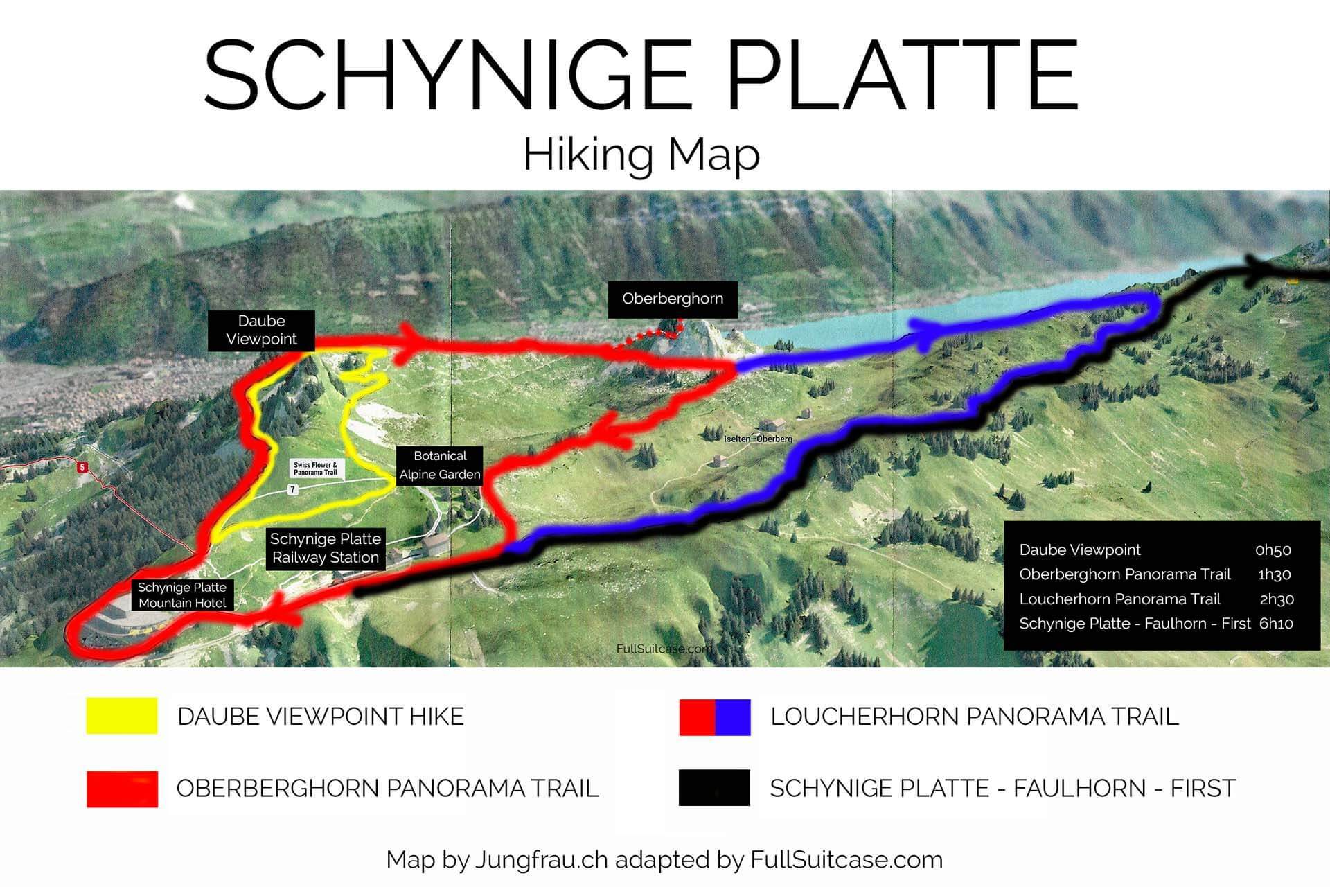
Map of Schynige Platte Hikes
To give you a better idea of where the hiking trails at Schynige Platte are located, we created this map indicating all four hikes mentioned in this article.
Good to know: Please note that the hikes listed here actually overlap – so hike 2 is a longer version of hike 1, and hike 3 is a longer version of hike 2. The first three hikes listed here start and end in Schynige Platte.
The last hike is a bit different – it’s not a circular hike. Furthermore, if you take the shortest route, you’ll not be passing the places covered by the other hikes. But you can take a detour and cover the same trail along the way if you choose to. More info further below.
You can click on the map to see the bigger version and print it out if you like.
Here are the best hikes at Schynige Platte:
1. Daube Viewpoint Hike
Schynige Platte – Daube – Schynige Platte
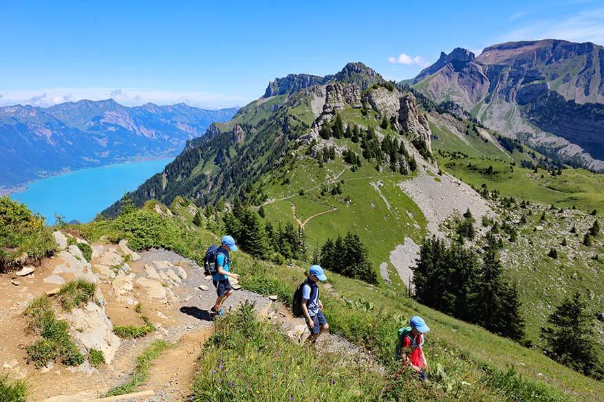
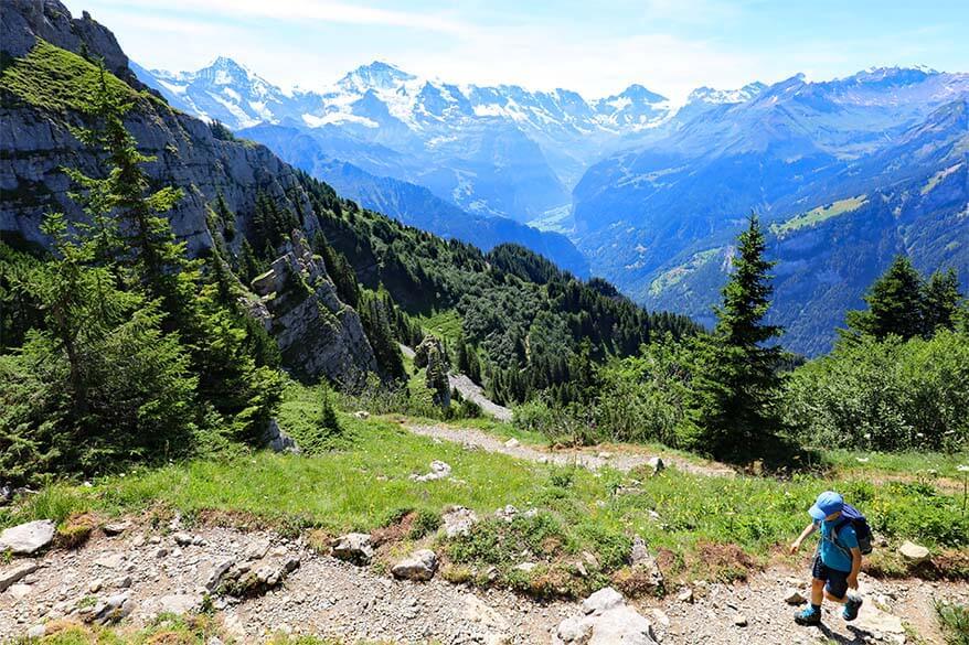
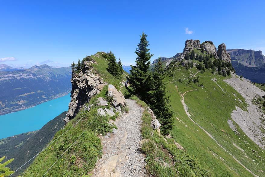
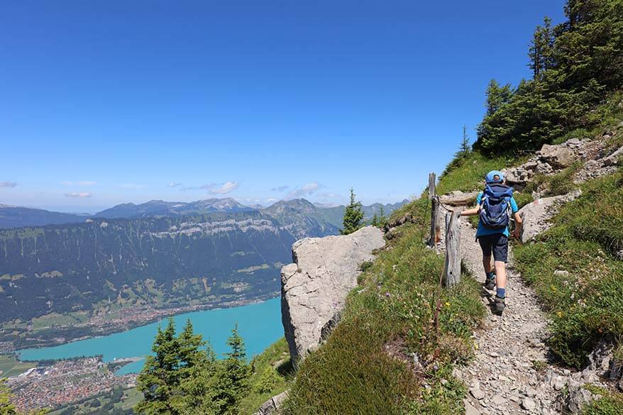
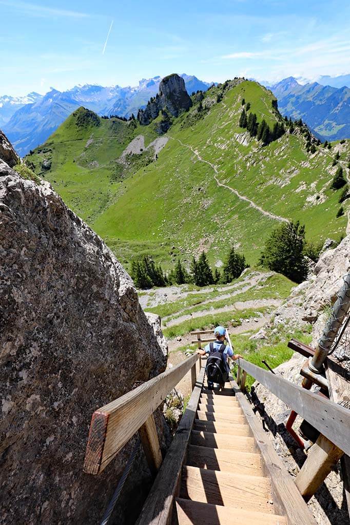
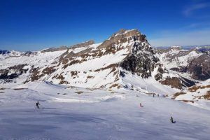
The Daube Viewpoint is probably the most popular hiking trail at Schynige Platte. It’s the shortest of the Schynige Platte hikes that gives you access to some of the best views in the area. This hike starts at Schynige Platte and brings you to the Daube viewpoint.
You can start the hike at the Schynige Platte hotel restaurant, above the summit train station. Alternatively, you can hike to Daube after visiting the Alpine Garden. It’s a circular hike and you can do it in any direction, but I think it’s nicer to hike clockwise – that way, you have splendid views in front of you most of the time.
We hiked several paths of the Alpine Garden first, then walked back in the direction of the hotel, where we joined the hiking trail to the Daube viewpoint. This part of the trail is going uphill and follows the mountain ridge, giving you yet another angle and good views of the wide surroundings. The scenery here is really nice, but it’s just the beginning…
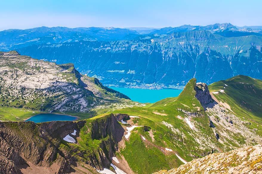
Once you reach the Daube viewpoint, you have great 360° views of the entire wide area. However, the nicest scenery is actually a bit further in the direction of Oberberghorn, so I really recommend that you do the longer version of this hike – see further below.
TIP: Daube viewpoint is a very popular picnic spot. If you bring a picnic for this hike, this might be a good place for it (although it can get really busy around noon).
Practical Information
- Difficulty level: Easy.
- Length and duration: 2.4km, 50 minutes (realistically 1h – 1h15).
- Ascent/ descent: 150m/ 150m.
The times and the distances listed here are for the entire hike.
This hike is relatively easy, despite the climb. It’s something most people in regular physical condition can do, and we saw many families with young kids and older people hiking here. If you have some hiking experience, you can do it. As for the children, most kids from the age of 5 should be able to do this hike as well, but it depends on their previous experience, of course.
READ ALSO: Interlaken Day Trip
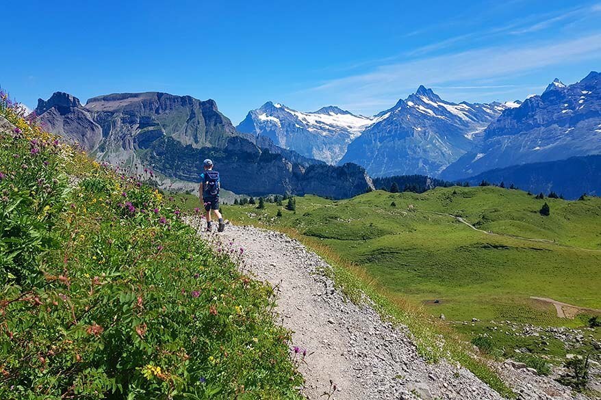
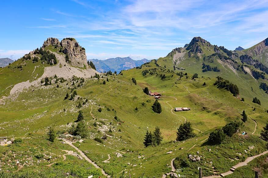
2. Oberberghorn Panorama Trail
Schynige Platte – Daube – Oberberghorn – Schynige Platte
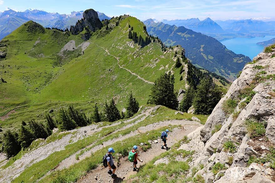
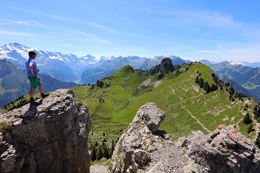
Oberberghorn Panorama Hike is the longer version of the Daube viewpoint hike. This is by far the best Schynige Platte hike with the most amazing views!
If you already hike in the area and take the trouble to walk to Daube, don’t stop there! The hardest part of the hike is actually the climb to the Daube viewpoint. From what I saw, many people just turn around here and go back. However, the hike gets much easier after Daube, and the views along the way to Oberberghorn are extraordinary. It’s this next part that really makes the hike worthwhile, so don’t miss it!
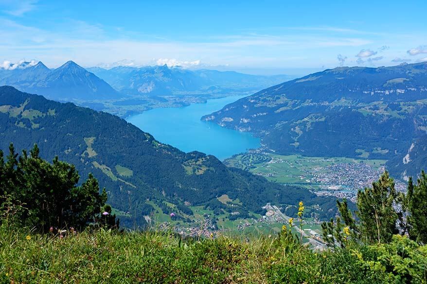
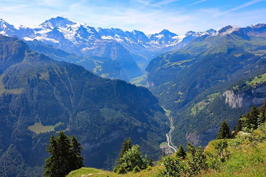
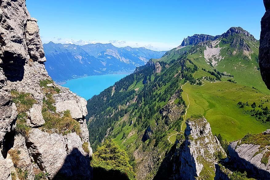
The trail from Daube to Oberberghorn takes you along a mountain ridge with incredible 360° views all around you. With the colorful lakes of Interlaken on one side, the snow-capped mountains of the Jungfrau Region on the other side, and idyllic alpine pastures right under your feet, this is one of the most scenic hikes in entire Switzerland!
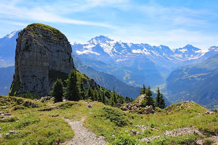
Once you reach Oberberghorn, make sure to climb up to the viewpoint itself. You’ll need to negotiate a short, steep ascent and a steep wooden staircase, but it’s really worth it. The views here are the best in the entire area!
Our kids, ages 8-10, did this hike without any trouble, and we met several other families with somewhat younger kids as well. Even if you don’t feel confident climbing to Oberberghorn, it’s still worth doing this hike.
You can turn back at Oberberghorn or hike further to Loucherhorn (see further below). Don’t feel bad for returning to Schynige Platte at this point, because you had the best views of the area with the least effort. The hike from Oberberghorn back to Schynige Platte is a relaxing downhill hike that has great mountain views all the time.
Practical Information
- Difficulty level: Easy/ Moderate.
- Length and duration: 3km, 1h15 (realistically, with photo stops, 2h).
- Ascent/ descent: 180m/ 180m.
The times and the distances listed here are for the entire hike.
This circular hike starts at Schynige Platte and goes to Oberberghorn. You can choose in which direction you hike, but it seems to me that it’s best to hike to the Daube viewpoint first and hike to Oberberghorn from there. We did the hike in this direction, and the views were great the whole time.
READ ALSO: How to Visit Jungfraujoch, Top of Europe
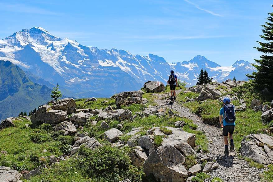
3. Loucherhorn Panorama Trail
Schynige Platte – Daube – Oberberghorn – Loucherhorn – Schynige Platte
This hike is the continuation of the previous hike (see above). After Oberberghorn, you can choose to continue hiking to Loucherhorn. This will add another 3km and at least an hour to your total hiking time.
This is a nice hiking trail, but I’m not sure if it’s worth hiking further. The very best views are between Daube and Oberberghorn.
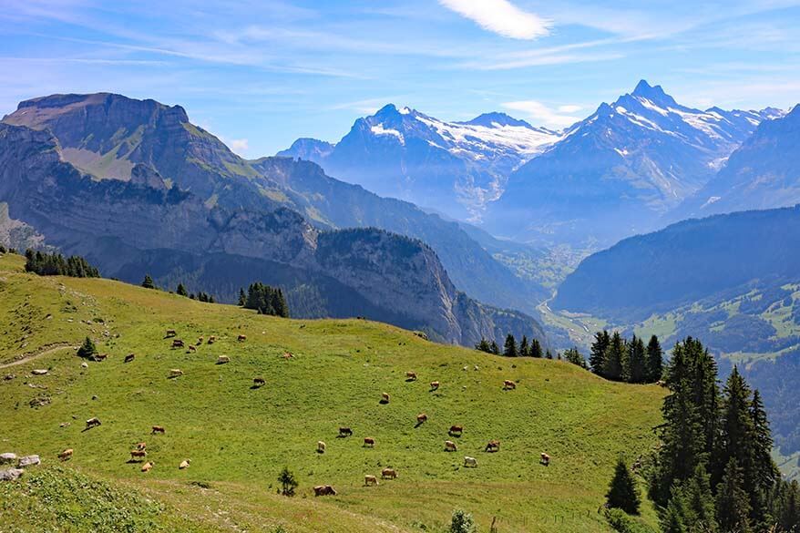
However, the scenery is really beautiful, there are very few people on this stretch, and so if you have the time and like to hike a bit more, you can definitely consider hiking to Loucherhorn. From there, join the path to your right that goes back to Schynige Platte. This trail is located much lower, and you’ll be surrounded by the green alpine scenery and probably also some Swiss cows along the way.
Practical Information
- Difficulty level: Moderate.
- Length and duration: 6.1km, 2.5h (realistically 3-3.5h).
- Ascent/ descent: 350m/ 350m.
The times and the distances listed here are for the entire hike.
4. Schynige Platte to First Hike
Schynige Platte – Faulhorn – First
Probably the most beautiful, but also the most challenging hike you can do in this area is the hike from Schynige Platte to First, via Faulhorn. This long hike is only for experienced hikers and takes an entire day.
You can do this hike in either direction – starting in Grindelwald-First or in Schynige Platte. If you are starting from Schynige Platte, you have 970m ascent and 770m descent. Therefore, most people choose to start in First (Grindelwald) and hike in the other direction – that way the climb up is slightly shorter and less strenuous.
The most impressive views of this hike are those from Faulhorn (alt. 2,681m / 8,796ft). From there, you can see a spectacular panorama over the region of Berner Oberland. On a clear day, you can see First, Mönch, and Breithorn, Lake Thun and Lake Brienz, Interlaken, and even the peaks of Mt Pilatus and Rigi.
TIP: Note that if you hike directly towards First (or the shortest trail from First to Schynige Platte), you’ll actually miss the Panorama Trail. And that would be a pity because it has the most amazing views, maybe even better than the rest of the long hike. So take a small detour via Daube and Oberberghorn and don’t miss the best views in the area. Just keep in mind that it will make your hike even longer!
Practical Information
- Difficulty level: Moderate/ Difficult.
- Length and duration: 16km, 6h10 (realistically 7-8h).
- Ascent/ descent (if starting from Schynige Platte): 970m/ 770m.
Good to know: This is a really long hike of at least 7 hours, counting just a few short stops along the way (longer if you stop more). Furthermore, you’ll need to take a train between Wilderwil and Schynige Platte and also a cable car between Grindelwald and First, so you have to keep an eye on the train/ cable car schedules. A general rule in summer is that gondolas/trains run from +- 8 AM to +- 6 PM.
Important: If you are planning to do this hike, take one of the first trains/cable cars in the morning and start as early as possible! It’s not a good idea to count on the very last train or gondola, so make sure that you reach the end point of your hike in time! Do not attempt this hike if there is a chance of rain or thunderstorms. Good hiking boots are essential for this hike, and I would definitely recommend hiking poles as well.
Tickets: A special hiking ticket is available that includes both – Schynige Platte train as well as the First cable car. You can find more information and book your ticket once you get there or on the regional website. Or – if staying in the region longer – get a Jungfrau Travel Pass that includes all these rides.
Travel well prepared, pack a picnic, and plenty of water. There are a few restaurants along the way, including several mountain huts and Berghotel Faulhorn. However, keep in mind that any stops will make your hike even longer.
Alternative for Schynige Platte – First Hike
We didn’t do Schynige Platte – Faulhorn – First hike because it was just too long and too strenuous to attempt with our kids. Also, we have hiked to Faulhorn before, pre-kids, and still remember the pain in our knees from the steep hike down.
What we did this time is hiking at the two ends of this trail – the Panorama Trail starting from Schynige Platte and the First – Bachalpsee hike starting from Grindelwald.
This is an easy way to see some of the most amazing scenery of this area without having to do the steep climb to Faulhorn or make any special travel arrangements. It does, however, require two separate days, but it makes for a much more relaxing vacation.
Practical Information
- When to go: Hiking at Schynige Platte is only possible in the summer season, typically late May/early June to mid-October. This year, the opening dates are June 13 – October 25, 2026.
- What to pack: You need really good hiking shoes with ankle support for any of these trails. Hiking poles are also good to have if you have weaker knees. Even the shortest hikes have some steeper sections that require a bit more caution. If you are curious about what hiking gear we use, my husband and I both have these hiking boots and these lightweight foldable hiking poles. Sun protection, drinking water, and a rain jacket are a must as well.
- Planning tip: Keep in mind that the indicated hiking times in Switzerland are hiking times. So if they say that a hike takes 1.5 hours, it’s purely hiking time if you walk at a good pace the entire time. You should always count more time for all the photo stops you’ll want to take. Add even more time for a picnic, bathroom stops, etc.
- Getting there: Schynige Platte can be reached by train from Wilderswil. It takes almost an hour one way. In summer, the trains run from +- 8 AM to 6 PM. When we visited, the first train left Wilderswil at 7.25 AM, and the last train left Schynige Platte at 5.53 PM. For more practical information about getting to Schynige Platte, please consult our detailed guide on how to visit Schynige Platte. It contains more information about everything else that you can see and do at Schynige Platte, in addition to hiking. Check it out!
More tips for your trip to Switzerland:
- Things to Do in Grindelwald-First
- First Cliff Walk
- Trümmebach Waterfalls
- Jungfrau Region in Winter
- Best Things to Do in Lucerne
- Lucerne to Mt Pilatus: How to Visit
- Best Day Trips from Lucerne
- Best Things to Do in Bern
- Top Things To Do in Zermatt
Some of our favorite hikes in Switzerland:
- Oeschinen Lake & Oeschinensee Hike (Central Switzerland)
- Hiking in Zermatt
- Matterhorn Glacier Trail (Zermatt)
- Gornergrat Scenic Trail (Zermatt)
- Four Lakes Hike (Engelberg)
- Best Hikes at Schynige Platte (close to Interlaken)
- Bachalpsee Lake (Grindelwald)
- Riffelsee Lake Trail (Zermatt)
- Stoos Ridge Hike (Close to Lucerne and Zurich)
- Charles Kuonen Suspension Bridge (Randa, Zermatt)
- Five Lakes Trail Zermatt
TIP: Save this guide for later, share it with your friends, or pin it to Pinterest so you can easily come back to it when planning your trip.

Hi
First of all thank you for this informative post. Its very helpful.
Question regarding the Daube trail – for a complete newbie
How narrow is the trail from the restaurant at Schynige Platte to Daube view point – a few videos I saw made it look narrow and with quite a steep fall off one one side. Also is it level or does it involve climbing and uneven terrain. I know the trail is classified as easy – but I am thinking “easy” may mean different things for different experience levels.
Asking in context of a person in their 60s who has never hiked as such before only walked on flat surfaces and has a bit of arthritis.
Is it worth it to go for a bit on this trail and then return – even if the entire loop cannot be done.
Thanks
Hi Mita, there are several ways to get to the Daube viewpoint from the station/hotel. While none of the trails are extremely narrow or have very steep fall-offs, they do involve uphill hiking on uneven terrain. You can see what one of the trails looks like in the picture under point #1. This is the trail that is indicated in red/yellow on our map. I think the yellow one (the middle part) is a bit less steep, so maybe you could try that and see how it goes. The main reward of this hike is the view from the viewpoint at the ridge and not from the trail to it, so – in my opinion – it’s not worth hiking just a part of it unless you actually get to see the lakes (the views in the other direction can be enjoyed without much hiking). What you can do is walk to the Botanical Alpine Garden and see how that goes, and then decide if you want to hike further. You don’t have to decide this in advance.
It’s still worth going to Schynige Platte even if you can’t do any of these hikes. The scenery is spectacular. You may want to check our guide to visiting Schynige Platte for more information.
Hope this helps.
Thank you very much for your reply. I will take your advice and after seeing the Alpine Garden see how I feel.
Hi Jurga, thanks so much for your very prompt response. I have noted the information you have given me and will use that for our hikes. If I have any other queries, I will ask you if okay. Thankyou again, have a lovely day. Cheers Tania
My name is Tania, I’m from Perth, Western Australia and my husband and I began planning our trip January 2024. I have been researching many hikes in and around Zermatt, Montreux, Interlaken and Bern, places we are staying when we arrive July – August 2026. I came across your website and have found it to be a valuable planning tool. Your information is so informative, simple and concise that I have written out many tips and paths to take. I am looking for maps to be able to download or even where to find paper copies of maps of hiking trails in Switzerland.Hoping you maybe able to recommend where to find. Thankyou so much for your website, it’s fantastic.
Cheers Tania and Dave
Hi Tania, in Switzerland, you will find free maps with the main hiking trails at the train/gondola stations of each area you are visiting. In addition, they usually have big signs with a map of the area – either at the bottom gondola station or at the top, often both. We always take a photo of a map for a quick reference. So if you are doing simple day hikes, you don’t really need to worry about this or buy any maps. You can also research photos of these maps online and save them to your phone, but we never bother. Switzerland is really well organized when it comes to things like this.
Just keep in mind that the Swiss hiking times are very ambitious – so if they say the hike takes 1 hour, it’s purely hiking time at a steady pace. In many cases, it takes longer, especially if you stop for photos, etc.
Have a great trip!
Hi Jurga,
Just like you, I have been traveling and exploring new places initially by myself starting in 1997, and with my family since my 2 boys got big enough to start enjoying the trips for the past 10 years. I also spend many many hours reading blogs and watching videos to plan the perfect trip for my boys, and this year I stumbled upon your site. I must say you have one of the nicest and most well rounded and thorough information I have come across. Great job, and keep up the good work. You have inspired me to consider starting my own blog and share the details of the places we have visited to help others like you have been doing.
Wish you all the best
Ravi
Thank you for your kind feedback, Ravi. I really appreciate it.
As for starting a blog, this is the most challenging moment to consider it. With all the AI content flooding the internet and search engines giving (not always correct and often illegally copied) answers to people directly without them ever having to visit the source of the information, many bloggers who have been doing this for a decade or even longer have been forced to look for another job. It’s also a lot more work than it might look like… Just so you know what you might be getting into ;).
Anyway, enjoy Switzerland. Schynige Platte is one of our favorite places!
Hi! love your blog, such useful info here 🙂 I was wondering if it’s possible to do the whole loop, i.e. from (Schynige Platte to Fauhorn to First), loop back to Oberberghorn before reaching First, and then follow the Oberberghorn Panorama Trail to Daube viewpoint and back to Schynige Platte. Referencing the Schynige Platte hiking map on your blog, it would be the black route with the blue and red routes (the whole outer loop). Would you know how long that would take? I’m okay to do multi day hikes and was wondering if this route would be the perfect 2 day hike 🙂
Thanks in advance,
Chris
Hi Chris, I’m not sure I follow your reasoning or what you mean by ‘looping back to Oberberghorn before reaching First’ (those two are quite far away from each other – you can’t see First on the map because it’s way more to the right). But yes, if you absolutely want to walk from Schynige Platte to Grindelwald-First and back, it is possible. And indeed, you would need to do it over two days. There are hotels at both places (Berghotel Schynige Platte and Berggasthaus First), so depending on where you start, you can stay at the other end.
Whether it’s actually worth it, I don’t know since the majority of the route would be the same just walking in another direction (and more uphill if coming from Grindelwald-First to Schynige Platte). The nicest part at Schynige Platte is following the ridge, aka Panorama Trail (Daube Viewpoint to Oberberghorn) so you don’t absolutely have to do the whole loop there to see the best scenery.
Another way to do this in a more relaxing way is to stay at the hotel at Schynige Platte the day before you do the hike and then start very early in the morning so that you can do the Panorama Trail and walk all the way to Grindelwald-First on the same day (so start with the top part of the red line, then blue, and then black all the way to First). It would give you a few extra hours and make the day less rushed. We also really love staying in mountain hotels in Switzerland. It’s always such a great experience to be ‘all alone’ on the mountain when day tourists leave and before they arrive again. Sunsets and sunrises can be amazing too.
Hope this helps. Enjoy the hike!
@Jurga, thank you for the response and suggestions! very helpful 🙂
Hi Jurga, coming back to this comment, I’m actually looking for the best possible views haha – would the view be better if I do just the schynige platte – faulhorn – first hike or like what you mention, the oberberghorn panorama trail (schynige platte – daube – oberberghorn) and then follow the loucherhorn panorama trail to first? not sure how long that would take as I would like to do the cliff walk at first as well as the mountain karts
Hi Chris, the views are amazing everywhere on this hike. And yes, Panorama Trail will give you access to some really nice views at different angles. However, even the shortest hike from Schynige Platte to Grindelwald-First will require a full day. If you are a very good hiker, are used to Alpine hikes, and don’t mind adding yet another hour or so to an already long hike, then yes, I assume you could add the Panorama Trail section to this hike. But I can’t really estimate how long it will take you – everyone hikes differently.
I recently had someone comment on another much easier hike that they seriously underestimated it. It appears, they are not used to hiking at all, they ‘prepared’ by taking daily walks around the block at home in Florida, and wore sneakers… So if you recognize yourself in this description, just stick to the Panorama Trail at Schynige Platte (even that might be challenging for many!) or Bachalpsee hike from First (which is much easier). Please only do this entire hike if you have hiking experience, are in top shape, have proper hiking gear, and if the weather is good.
If you decide to do it, start at Schynige Platte first thing in the morning (take the very first train up) – that way, you will be more relaxed during the rest of the day. And once you get to First, you can see what time it is and how busy it is everywhere before deciding what/if you can still do there. And if it turns out that you are extremely quick, well, you’ll just have more time to enjoy the scenery along the way and the activities at Grindelwald-First.
got it! fitness shouldn’t be an issue – I do trail runs, just gauging the time I need roughly haha. Does the Loucherhorn panorama trail meet up with the schynige platte – faulhorn – first route? Currently I’m thinking i should do the oberberghorn panorama trail starting at schynige platte, and from oberberghorn continue with the loucherhorn panorama trail, then head to First. Would this route still bypass bachalpsee?
I’m not sure if the views for the abovementioned route would be better than the direct schynige platte – Faulhorn – First route. are you able to advise? thanks so much Jurga.
Hi Chris, you may want to take a look at the map of this hike here. Wait for the page to fully load and then zoom in on the map and you will see exactly where it goes and how it could connect with the Daube Viewpoint/ Oberberghorn Panorama Trail. And yes, it passes Bachalpsee.
I don’t know exactly how much time you would have to add if you decide to make the detour at Schynige Platte, likely less than an hour extra compared to the regular route, maybe just half an hour – I really don’t know. Is it worth it? Yes, the views are amazing because you hike close to the ridge. In my opinion, the views between Daube Viewpoint and Oberberghorn are among the very best in Switzerland. But you will have amazing views everywhere on that hike! It’s just different.
Can you do it? I don’t know. We didn’t do it that way. But if you can do a 16km Alpine hike, then I guess you can add another kilometer or two as well. Again, if you start early and are very fit, yes, it should be doable. Count at least 7 hours of pure hiking time. Keep in mind that the Swiss hiking times are really ambitious, so if they say the Schynige Platte – First hike takes 6 hours, I would count at least 7 hours, likely even 8 with all the stops, lunch, etc. If you add the detour on the Panorama Trail to it, count that the whole thing might take you 9 hours. Maybe you can do it faster, but it’s better not to have to rush.
If you see that you can’t make it to First on time, you can always take a detour and head down a bit earlier. For example, there is a hike between Faulhorn and Bussalp (about 1h40) from where you can take a bus down to Grindelwald town (you’ll need a separate ticket for the bus). It’s a steep descent, a bit tough on your knees, but it’s an option if the entire hike turns out to be too much or if you see that you won’t get to First in time for the last gondola.
Also further down the route there are various options to hike down, e.g. the Flower Trail between Bachalpsee and Bort (2.5 hours).
PS Make sure to pick up the map of the hiking trails before you start and check train/gondola/bus schedules, just in case. You can find all this information online and at all the train/gondola stations in the region, and you can always ask for route suggestions at the mountain huts if you need help with something.
I hope this helps. I’m afraid I can’t help you further. Whatever you decide, be careful, adjust your plans if needed for whatever reason, and have a great hike.
Hi Jurga, THANK YOU for your comprehensive guide and spectacular photos from Schynige Platte. My daughter and I will be there on May 14, 2024, thanks to your blog. It’s a bucket-list experience for me (I’m 75) but working daily on my stamina to walk the Oberberghorn Panorama trail. Do we need to reserve tickets to get from Wilderswil to Schynige Platte or is arriving early in the morning enough to ensure we have a seat on the train? Thank you again and blessings to your family and your travels. You’ve enriched the lives of so many
Linda R
Hi Linda, thank you for the kind feedback. However, I’m afraid I have to disappoint you – Schynige Platte isn’t accessible in mid-May. In some years, the season starts at the end of May, but I see that this year it’s foreseen to open from the 15 of June.
What you could do instead is visit Harder Kulm in Interlaken, Grindelwald-First, and Jungfraujoch. It will likely be too early for most hikes, depending on the snow conditions and how warm the spring will be. But these places are all accessible at that time of the year and you can enjoy amazing scenery without much hiking.
Have a great trip!
Schynige Platte to First was the best day hike we ever did, and I urge well-conditioned hikers looking for a bucket-list journey to consider it. First, make sure you will have good weather. If you run into clouds or fog all your effort will only get you a long cardio workout rather than the most spectacular views of your hiking life. We settled in Interlaken for several days, keeping an eye on the weather in the mountains (your innkeeper will likely be a good source of weather information), and doing shorter hikes or short rail trips when the weather up high was not conducive to a long day. Second, make sure you start early, as the hike will take at least 7 hours. check the gondola schedule at Frist, your destination, as you don’t want to be stuck in the mountains overnight. Of course, you need good sturdy well broken-in hiking boots, as the trail is uneven and often rocky. We did the hike at ages 61 and 57, so you don’t need to be young and super-fit to do it (my wife wasn’t even doing regular exercise at the time, though she is athletic, light, and nimble).
Thanks for sharing your experience, Ray. I’m sure it will help others to get a better idea of what to expect and what can be done.
Hello! If doing Schingye Platte to First or vice versa, is it easy to spot/include the Panorama piece. I am struggling with fully understanding this. Also, how much distance/time does it add. Thank you.
Hi Daryn, yes, you can easily add Panorama Hike to your hike from Schynige Platte to Grindelwald-First via Faulhorn.
Upon arrival in Schynige Platte, instead of following signs directly toward Faulhorn, head to Daube viewpoint first. From there, you pretty much follow the ridge and there will be signs.
As for how much hiking time this adds, it really depends on how fast you hike. I think that it shouldn’t be more than an hour extra, maybe even less if you are a good hiker.
However, I really recommend starting as early as possible so that you get to Grindelwald-First in time before the gondolas close. Otherwise, you’ll have to add quite a steep and very long hike down to town.
Hope this helps. Have a great trip!
@Jurga, Thank you so much!
Greetings! I so enjoyed your blog and all the wonderful information you shared! We are planning our first trip to the Jungfrau Region and the hikes you identified has really helped to create our to do list (especially as seniors!) I look forward to to reading more. Thank you for sharing your experiences with us.
Glad to help.
Have a great trip!
Your blog is the BEST!!!!!!!!!!!
We are going to Murren then Wengan for the first time. We are having a hard time finding information on hikes around Wengan. We do easy-moderate ones. Murren is our favorite. We have hiked that area and are excited to do it again with your recommendations. Would you recommend Wengan? How many nights would you stay there?
Hi Terri, I personally prefer Wengen over Mürren because of its more central location (it’s just a bit easier to visit the entire area from there vs Mürren). But they are both wonderful.
For hiking, there are so many choices that it’s difficult to suggest. In Mürren, we love the hike between the gondola station and the town (so instead of taking the train, you take the upper path to Murren).
In Wengen, the musts are two short hikes at Männlichen – the Royal Walk and the Panorama Trail to Kleine Scheidegg. You can do both together in around 1.5-2 hours and it’s very relaxing. You can also hike from Kleine Scheidegg down to Wengen, or – a bit more challenging – the Eiger Trail from Eigergletscher to Alpiglen, and then the train back to wherever you need to be. Also the Bachalpsee hike in Grindelwald is very nice and easy. And the Schynige Platte hikes mentioned in this article too.
As for how long to stay, it’s really up to you. We’ve been to the region so many times, staying anywhere from 2 to 10 nights in one trip, and we always find things to do. Our last summer trip to Wengen was 10 nights and we never got bored. It all depends on what you want to see and do. We normally count at least one full day per area (so a day for Kleine Scheidegg/Jungfraujoch, a day for Grindelwald-First, a day for Mürren, a day for Interlaken, a day for Schynige Platte, at least half a day for Lauterbunnen/Trümmelbach, etc.).
Hope this helps.
Jurga,
Words cannot express how thankful I am to you, and for the time you dedicate to your travel blog. This summer my husband and I traveled to Switzerland for the third time, (from US) but, thanks to so many of your recommendations, we were able to hike and see some of the most beautiful places on earth. Oeschinensee at Kandersteg was our favorite too (despite 28K steps that day!) and Schynige Platte was a close second. I felt so much more confident hiking after studying and printing out your pages for these hikes. We also did Grindelwald-First (for the first time) and I’m sorry the kids weren’t old enough for the Trotti Bikes, they were a blast and I think we must have traveled 7-10 miles on them downhill! Also did Trummelbach Falls in Lauterbrunnen for the first time, and swam in Lake Brienz at Iseltwald for a couple hours on our way out of town. You are making me look like a fabulous photographer and world traveler with all your awesome suggestions. To be able to budget our expenses for travel, and then feel like we got soooo much more value this trip due to your suggestions really makes me grateful to you!
I have a few questions for you though… Why haven’t you been to Chamonix, France yet? It seems like it would fit well with what your family enjoys! Also, I noticed Germany hasn’t been mentioned any. We love the Zugspitze area of German/Austrian border, just thought it was odd that you haven’t blogged about Germany. (We saw The Passion in Oberammergau and it was amazing, such an accomplishment for a small town!)
Looking forward to “taking you on our next trip” soon! Maybe Iceland!!
THANK YOU, THANK YOU, THANK YOU!!!
Susan
Hi Susan, thank you for your kind feedback. It’s great to hear that our tips helped you plan a more memorable trip!
As for our travels, obviously, we haven’t been everywhere and our bucket list is endless. But we also visited many more places than we ever find the time to write about. Many – long before I started this blog, others – just recently. If you would know how long it takes me to publish a single guide, you’d understand why we can’t write about every place we go to… This is especially the case for our neighboring countries (France, Germany, the Netherlands) where many trips are rather short and different than the further travels where we spend more time planning, researching, etc.
So while I’m doing my best to write about as many places as possible, I also want to keep the blog personal and really useful. I am trying to provide more detailed information that’s truly helpful for people looking to plan a trip rather than some general info that you can find in any guidebook or impersonal blog. So to me, less is more.
As for Iceland, it’s such a unique country that I can only encourage everyone to visit at least once in a lifetime. We have tons of information and articles that should help you plan a trip no matter in which season or for how long you’d go. Take a look here: Iceland travel guide.
Happy travels and thank you once again for stopping by to leave this kind review.
Jurga
@Susan Merritt,
That all makes sense! And you are correct, I can’t even imagine the time you spend planning OR creating these awesome blogs for us to use! I’m anxious to start gathering info for Iceland from your recommendations… we are retiring in 2023 and we have so many plans! The husband is wanting to rent a RV and travel Europe, but I’m like, there’s NO WAY I want to give up those awesome European hotel breakfasts – like the one in Austria that had 17 cheeses, of which I had 13!
Wishing you and your family a lifetime of happy travels! We have finally realized these trips and experiences are so much better than material things!
Thank you, Susan! The same to you – many more amazing trips and great memories with your loved ones.
PS Wow, 13 kinds of cheese?! Hopefully not all at once. 🙂
Hello! Thank you for your information on the hikes! Your guides are very insightful and helping me a lot in planning my trip! 🙂 The hike length and duration for the Oberberghorn Panoramic Trail is stated as 3km and approximately 2 hours. Can I check if this is one-way from Schnynige to Oberberghorn? Thank you! 🙂
Hi Amanda, as already noted in the article, all the hiking times and distances are for the entire hike, so in this case, from start to finish from/back to Schynige Platte.
Have a great trip!
@Jurga, Hi Jurga! Oh thank you so much for explaining it to me again! I really appreciate it 🙂 Have a great day ahead!