Best Way to Do the Grand Balcon Nord Hike in Chamonix (+Map & Tips)
This site contains affiliate links, which means that we may earn a small commission, at no cost to you, for qualifying purchases. It supports the work that goes into keeping this content free. Thanks for reading! More info: Privacy Policy.
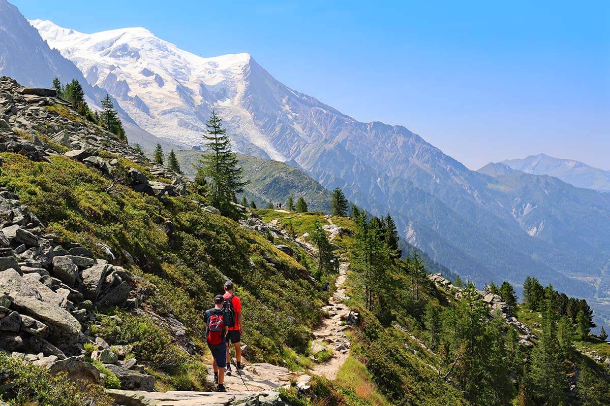
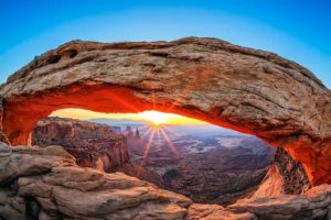
Grand Balcon Nord (High North Balcony) is the most iconic hike in Chamonix, France. Following the northern side of the mountains surrounding the Chamonix-Mont-Blanc Valley, this hiking trail offers jaw-dropping scenery and fantastic views of Mont Blanc.
The best and most popular part of the Grand Balcon Nord hike is between Plan de l’Aiguille du Midi (middle cable car station between Chamonix and Aiguille du Midi) and Montenvers – Mer de Glace (upper cogwheel train station).
Aiguille du Midi and Mer de Glace are the two main mountain peak destinations that you really have to see in Chamonix, whether you are hiking or not. But if you want to see some of the most remarkable mountain scenery in the area that cannot be seen from the train or the cable station, we highly recommend considering the Grand Balcon Nord hike between these two areas.
In fact, if you want to do just one hike in Chamonix, don’t look any further – Grand Balcon Nord is the very best choice! This hike includes all the main highlights of Chamonix in a few short hours.
In this guide, you can find all the information about this iconic hike: where to start, in which direction to hike and why (spoiler alert – it’s not what most guides tell you!), and where to find the best scenery. We also include a map and experience-based tips to help you make the most of your visit. Find out!
YOU MAY ALSO LIKE TO READ: Best Things to Do in Geneva (+ 1-day itinerary)
Hike Overview & Map
The Grand Balcon Nord is a one-way hike following the middle of the mountain with a rather limited elevation change. Since you can reach both ends of this trail by cable car and cogwheel train, this hike can be easily done in any direction. Further below, we explain which direction we recommend and why.
Here is a short overview of the Grand Balcon Nord hike:
- Start/end: Plan de l’Aiguille du Midi 2,317 m (7,602 ft) cable car station to/from Montenvers cogwheel train station at Mer de Glace (1,913 m (6,276 ft).
- Recommended trail: via Signal Forbes (2,200 m (7,218 ft) – the purple line on our map below instead of the red trail. More info further below.
- Difficulty: Moderate.
- Duration: 2.5 hours or 3 hours via Signal Forbes.
- Distance: 5.7 km (3.5 miles) or 6.6 km (4.1 miles) via Signal Forbes.
- Elevation change depends on the direction and the route chosen:
- Plan de l’Aiguille to Montenvers/Mer de Glace: 89 m (292 ft) up and 455 m (1,492 ft) down.
- Plan de l’Aiguille to Montenvers/Mer de Glace via Signal Forbes: 183 m (600 ft) up and 560 m (1,837 ft) down.
- Montenvers/Mer de Glace to Plan de l’Aiguille: 455 m (1,492 ft) up and 89 m (292 ft) down.
- Montenvers/Mer de Glace to Plan de l’Aiguille via Signal Forbes: 560 m (1,837 ft) up and 183 m (600 ft) down.
- Season: Summer months (+-June to early October).
- Facilities: Bathrooms and restaurants at both ends of the trail.
- Gear: Good hiking shoes are a must! Hiking poles are useful.
- What to bring: sun protection, water, and a sweater/windbreaker.
- Where to stay: Heliopic Hotel & Spa, right next to the l’Aiguille du Midi cable car, is very conveniently located for everything in Chamonix.
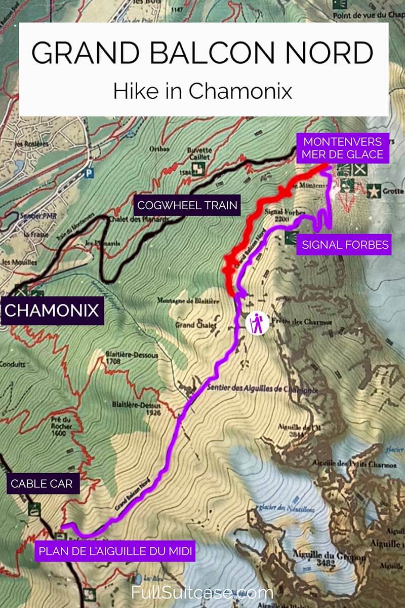
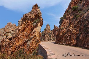
The Most Scenic Route – Signal Forbes Detour
The Grand Balcon Nord hike is one of the most scenic hikes in Europe, so no matter which route you choose, you will have amazing views. That said, if you are looking for the VERY BEST views, be sure to follow the detour via Signal Forbes (the purple line on our map above).
This route is a bit longer, a lot steeper, and it will take you about 20-30 minutes extra compared to the shortest trail. However, the official signs that you will find en-route show it as a recommended itinerary (itinéraire conseillé). There are several reasons for this. First, the scenery. And second, safety.
The trail between Montenvers-Mer de Glace train station and Signal Forbes offers unparalleled views of the nearby glaciers and the surrounding mountains. The 360° views at the top of Signal Forbes are spectacular too!
Whereas if you take the ‘regular’ Grand Balcon Nord trail (indicated in red), you will miss the best glacier views and will be looking at the Chamonix Valley most of the time. Furthermore, this part of the trail has some challenging, delicate sections (indicated with red crosses on our map above) with steep drops and some rock scrambling. The official signs warn you of a delicate passage (passage délicat) if you opt for this route.
Good to know: All in all, both routes are absolutely fine if you have hiking experience and know what to expect on Alpine trails. However, please read further before you decide to do this hike!
Who Is This Hike For?
Grand Balcon Nord trail is a beautiful hike that can be done by most people in good physical shape AND with hiking experience. You can also do this hike with children from about 6-7 years IF they are used to hiking and can handle a 3-hour hike involving some steeper sections.
We did this hike with our teenagers and – as usual – had to ask them to wait for us all the time. We also saw several families on this trail with younger kids (from +-7-8 years) and they all seemed to be doing fine. Better than some of the adults.
However, keep in mind that no matter which route you follow or in which direction you hike, the Grand Balcon Nord Trail is a moderate mountain hike and not a walk in the park.
We got the impression that too many people do the Grand Balcon Nord hike unprepared. This is a really worrying trend at many mountain destinations nowadays – people getting inspired by social media posts overestimating their ability and/or underestimating the hike.
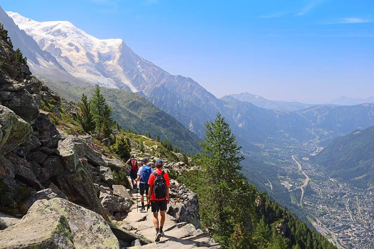
We met quite some people on this hike who looked like they never hiked before… At one point, we passed a small group of friends who were trying to convince a young woman in their group to hike further telling her that she had to finish the hike or sleep on the mountain. They started at Plan de l’Aiguille du Midi and at that point had hiked the easiest downhill section of less than a third of the trail, with the longest part and much more challenging sections still ahead of them…
So if you have never hiked in the mountains, or have any doubts about your ability, do yourself a favor and simply visit both ends of the trail by cable car and train. Also, don’t do this hike if the snow has not melted yet, if the weather isn’t great, or if you don’t have proper hiking shoes.
Further below, you can find a detailed hike description with some pictures that will give you a better idea of what to expect. But first, let’s take a look at the best direction in which to do the hike.
The Best Direction (Not the Easiest!)
Grand Balcon hike is a one-way hike between two mountain stations – Plan de l’Aiguille du Midi which can be reached by cable car and Montenvers-Mer de Glace which can be reached by train from Chamonix. So you can easily do this hike in any direction.
Since Plan de l’Aiguille du Midi (2,317 m – 7,602 ft) is located at a somewhat higher altitude than Mer de Glace (1,913 m – 6,276 ft), most travel guides will tell you to do the hike starting at Plan de l’Aiguille du Midi. However, a smaller elevation gain is the only reason to do the hike in this direction.
After chatting to people from a local tourism office in Chamonix, we chose to do the hike in the other direction, starting at Mer de Glace and ending at Plan de l’Aiguille du Midi, and I highly recommend considering doing it the same way.
If you are used to hiking, then you know that an elevation gain of 400-500 meters is not such a big deal (and it’s better for your knees to go up than down) and the reward in this case makes it more than worth it – see below.
Here are the main reasons to do the Grand Balcon Nord hike starting at Mer de Glace:
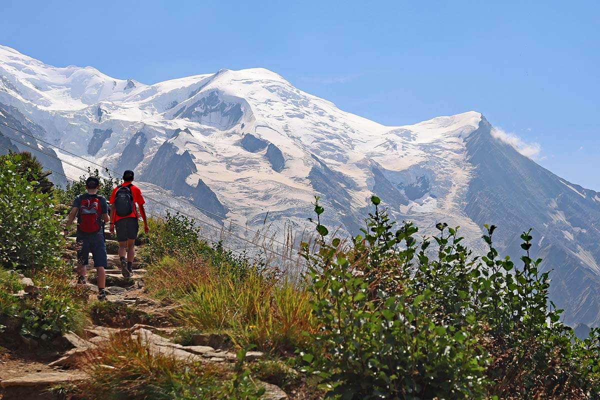
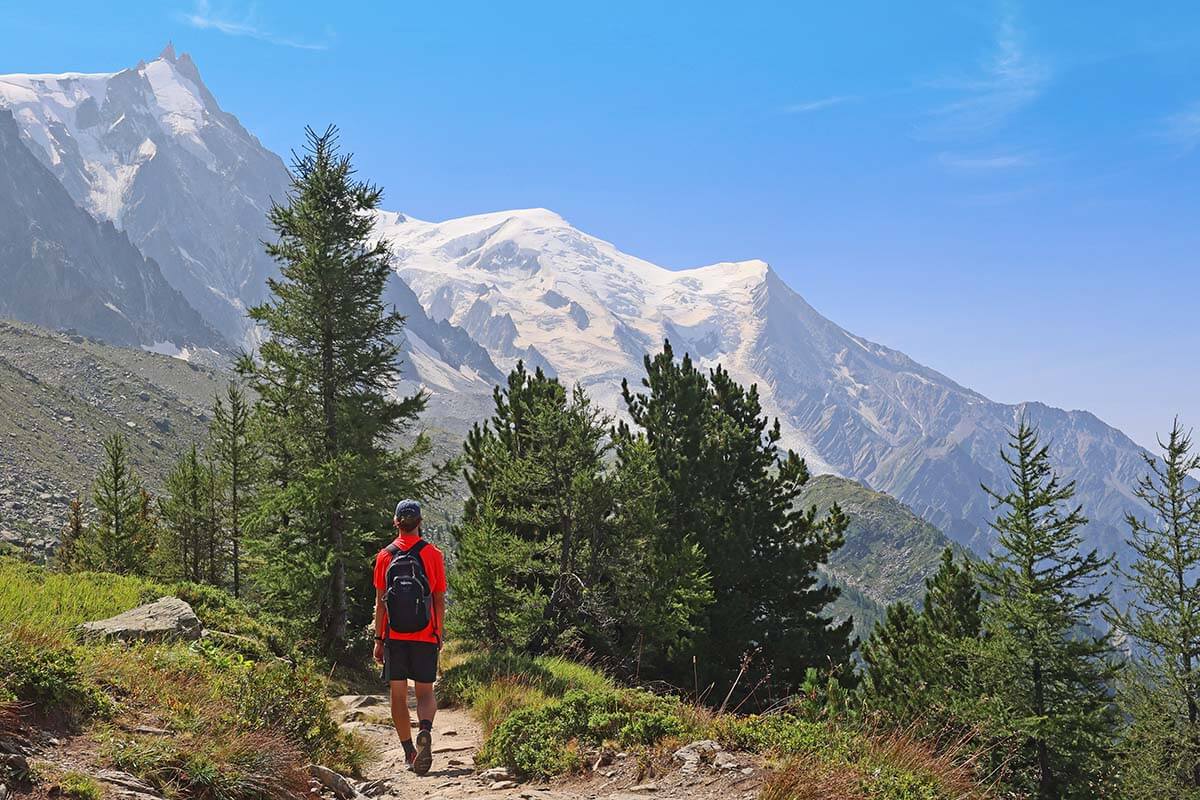
- The views. You will be hiking toward the best view (Mont Blanc), so the hike is much more scenic. below, you can see two pictures that give you a good idea of how the views compare depending on the direction you choose.
- The sun. If you start at Plan de l’Aiguille du Midi, you will have the sun in your face all the time, whereas starting at Mer de Glace the sun will be behind you.
- No reservations. L’Aiguille du Midi is the most popular mountain excursion in Chamonix and the cable car to go up the mountain has to be reserved (in the high season, at least several days in advance!). In the meantime, the Montenvers train requires no reservation, making it much easier to plan your visit (or adjust based on the weather).
- Fewer crowds. If you take the earliest train, you will be able to explore Mer de Glace (viewing platforms, ice cave, etc.) without big crowds. You will also meet fewer people doing the hike in the same direction as you, which makes it easier to hike at your own pace. And if you plan to visit the mountain peak of l’Aiguille du Midi after doing this hike, it will be much quieter there too since most day trippers will be gone by the time you get to the top. Just keep in mind that if you want to do all this on the same day, it’s best to take the very first train in the morning (normally, at 10 AM).
LEARN MORE: How to See the Best of Chamonix in 1 Day
Furthermore, if you start at Mer de Glace and make a detour to Signal Forbes, you will do the steepest part of the trail in the beginning, making the rest of the hike more relaxing. Otherwise, you start rather easy and have a tougher part of the hike toward the end.
But even if you opt for the shorter route without a detour, the Grand Balcon Nord trail closer to Mer de Glace has several more challenging sections. It’s easier to do those at the beginning of the hike rather than at the end, after you have been hiking for 1.5-2 hours.
Grand Balcon Nord Hike Description & Photos
Below is a short overview of the Grand Balcon Nord hike as we did it, starting at Mer de Glace, going via Signal Forbes, and ending at Plan de l’Aiguille du Midi.
If you do it in the other direction, it will be somewhat easier (less climbing), but make sure to turn back once in a while because the best views will be behind you most of the time.
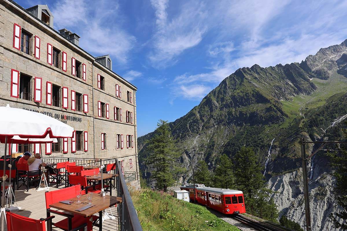
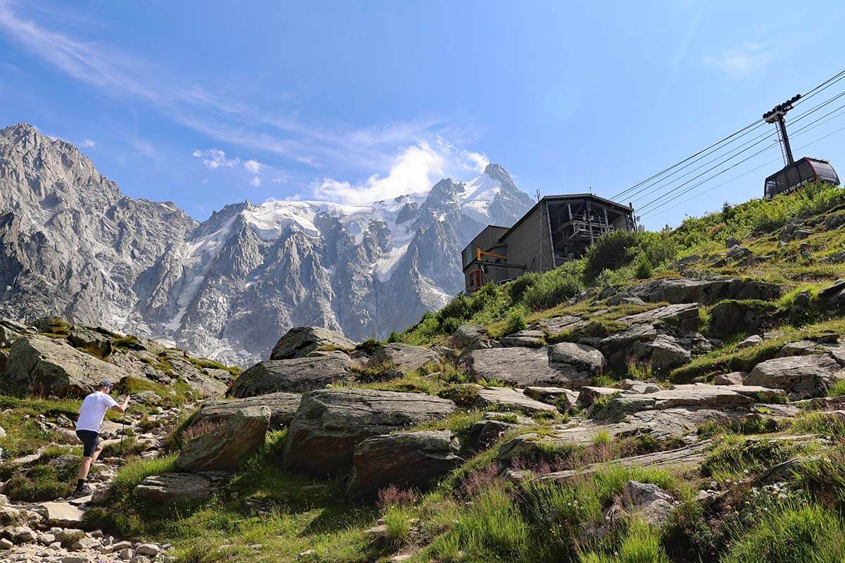
Start at Montenvers Train Station
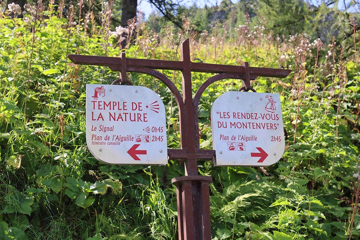
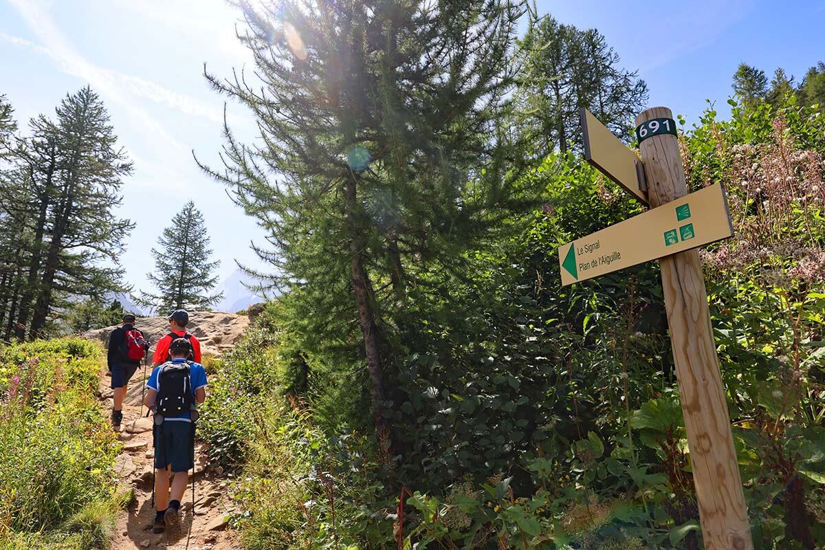
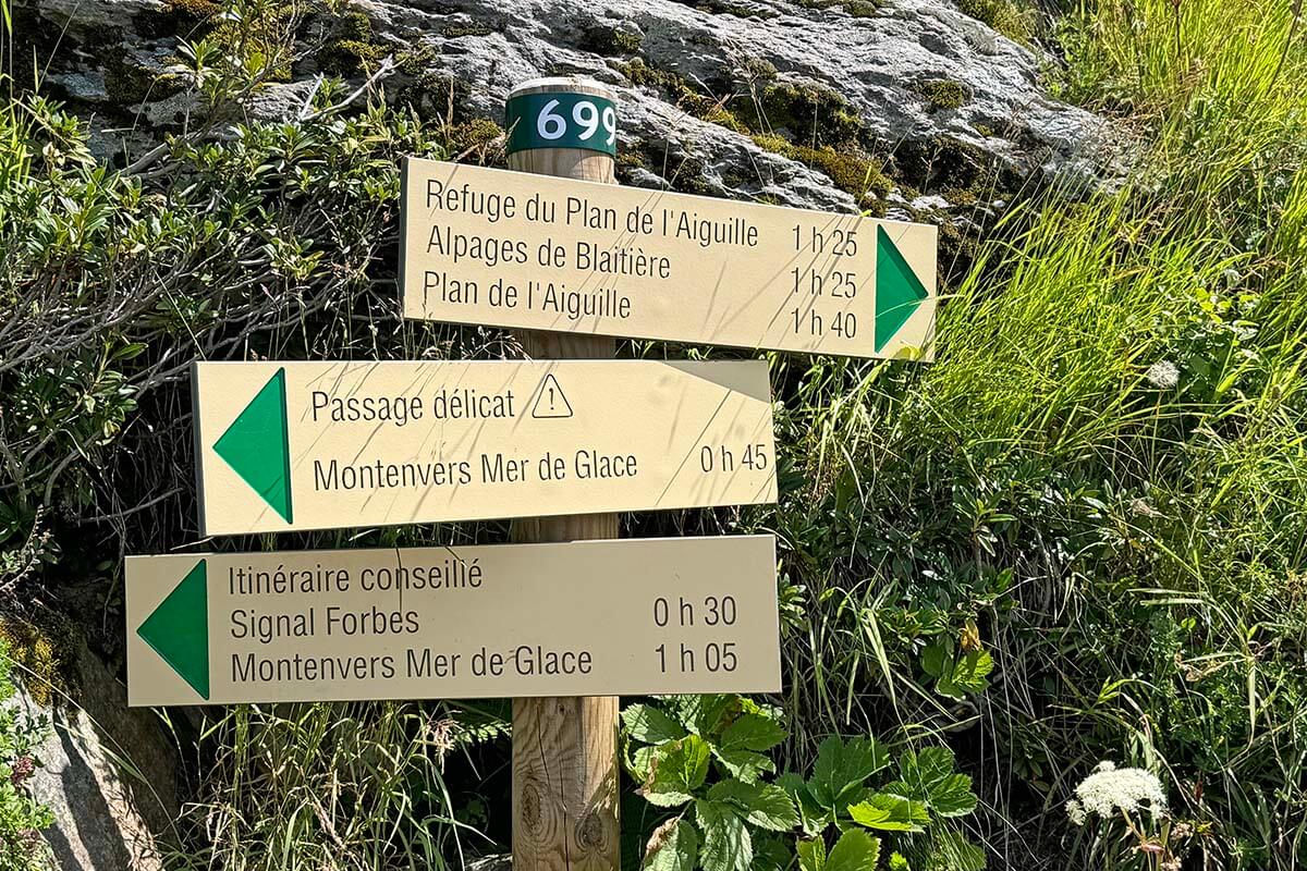
After taking the Montenvers train to Mer de Glace and exploring everything there, locate the starting point of the Grand Balcon Nord Trail. It’s not really indicated under this name, but don’t worry – it’s easy to find. What you are looking for are the signs to Plan de l’Aiguille du Midi or Signal Forbes (also indicated as ‘Le Signal’).
After leaving the station, walk in the direction of the Grand Hotel and Glaciorium. Once you pass the hotel terrace, start looking out for hiking signs.
The signs to Plan de l’Aiguille du Midi point left and right, because there are two ways to do this hike. One sign indicates the left route – via Le Signal – as ‘itinéraire conseillé’ (a recommended route). This is the route we followed and that is described below.
TIP: Don’t forget to use the bathrooms at Montenvers train station. Once you leave, there will be no facilities until you reach the Refuge du Plan de l’Aiguille, which is located just 15 minutes before Plan de l’Aiguille itself, so pretty much at the end of the trail.
Montenvers Station (Mer de Glace) to Signal Forbes
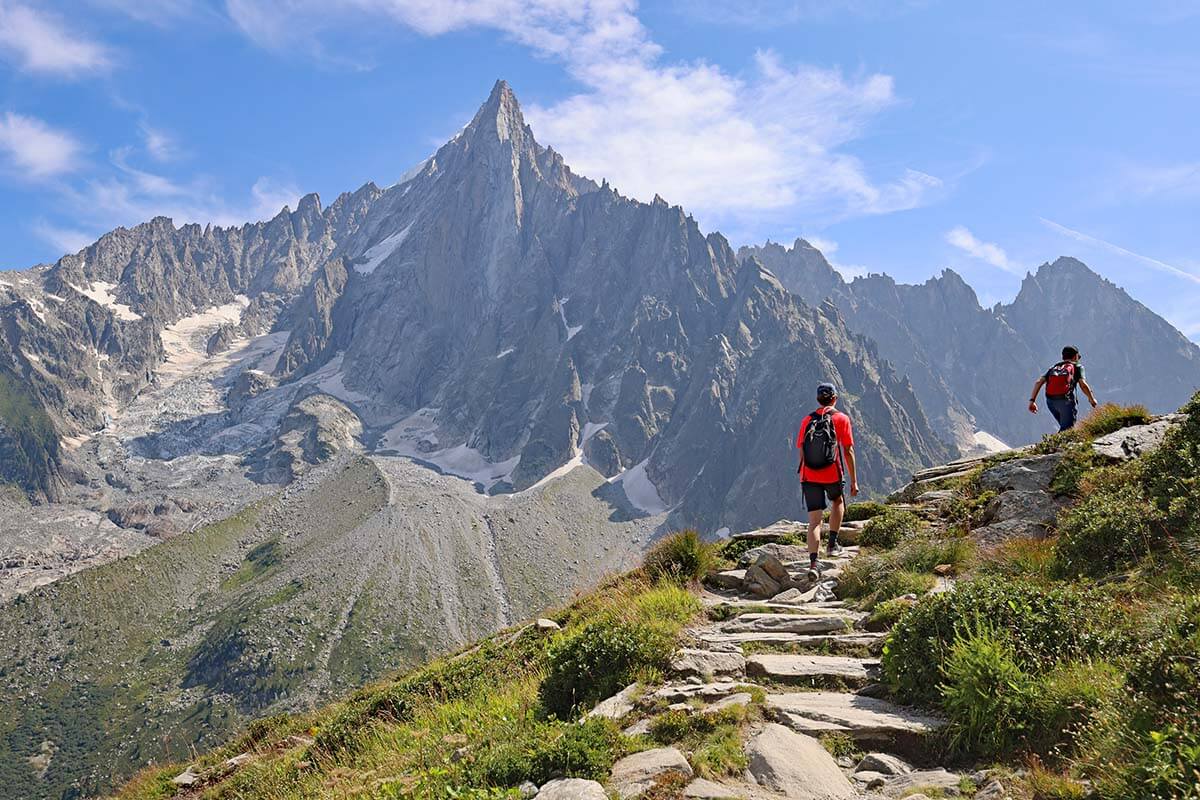
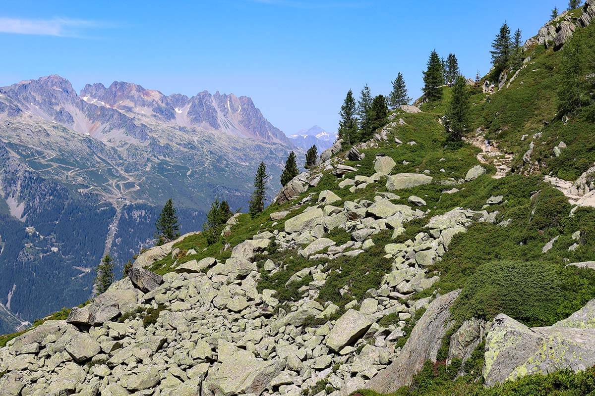
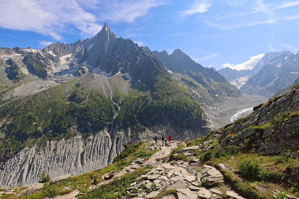
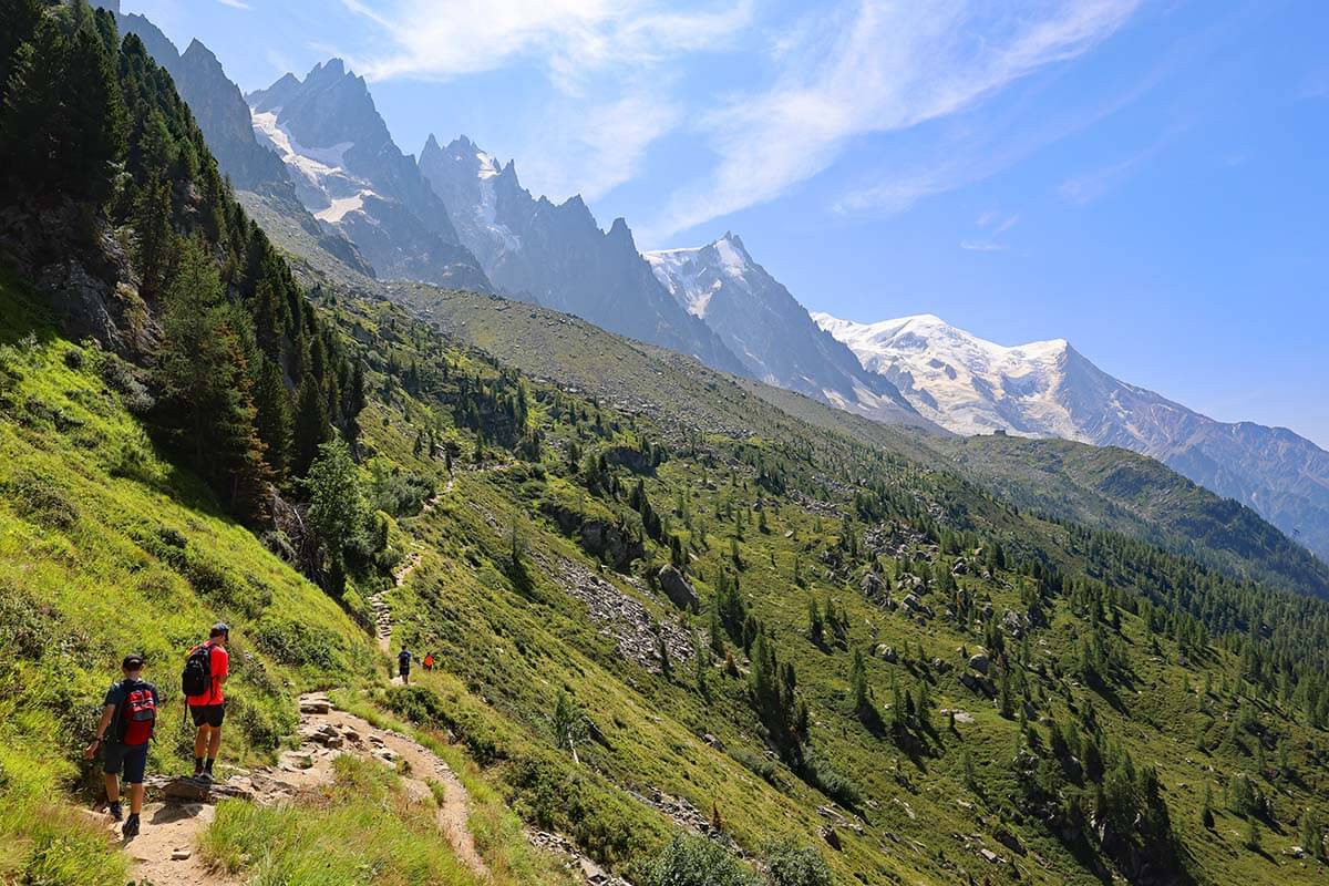
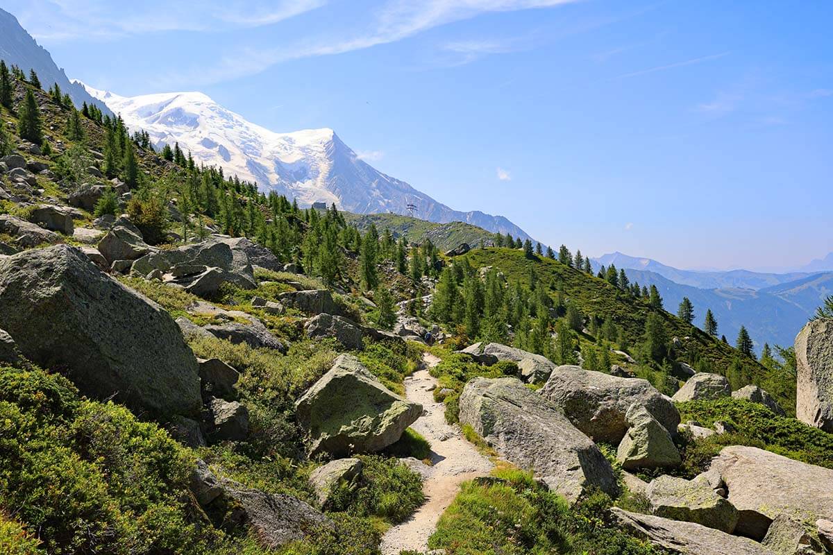
If you also choose to hike via Le Signal, you will follow the trail to the left and will be walking back toward the Mer de Glace Glacier. It starts going up pretty soon and you will be climbing pretty much all the time until you get to Le Signal.
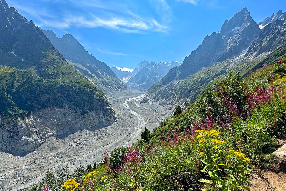
On this first part of the trail, you will be looking toward Mer de Glace Glacier pretty much all the time. Once you get higher, you will also have a very good view of the glacier of Argentière, a few waterfalls in the distance, and stunning mountain scenery in all directions.
Good to know: The hiking distance from Montenvers station to Signal Forbes is about 1.6 km (1 mile) and the elevation gain is about 300 meters (984 ft). It takes about 45 minutes to reach the top. This is also what the signs indicate and also the time it took us. We walked rather slowly, with lots of photo stops along the way. Our teenagers could have easily done this in half an hour, but not everyone hikes like mountain goats… 😉
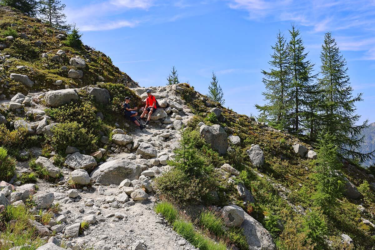
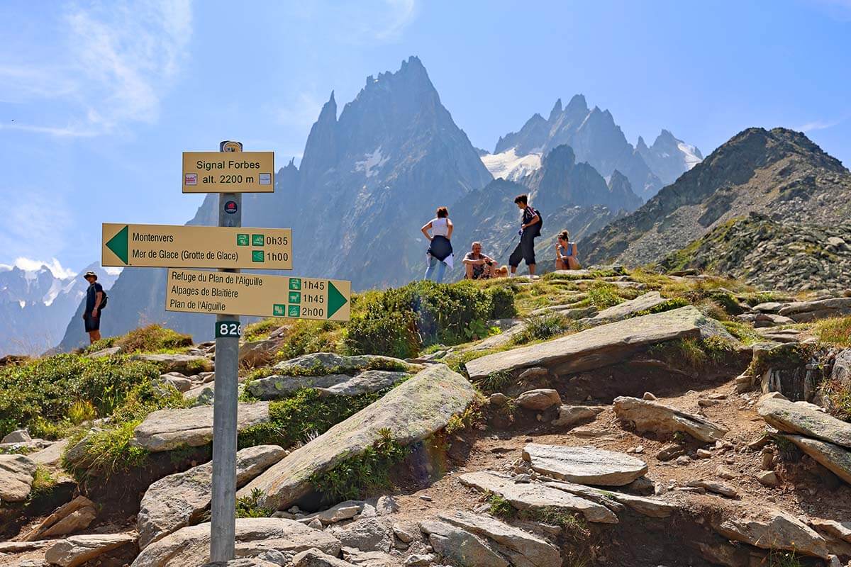
Signal Forbes & Lunch
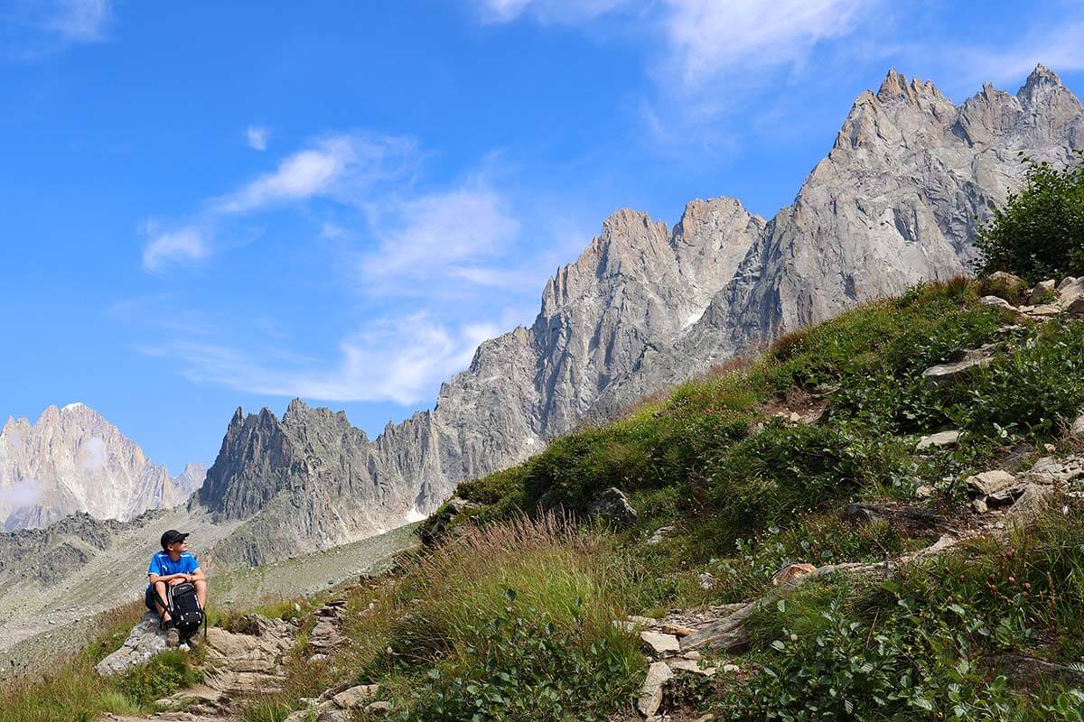
Once you reach Signal Forbes, the steepest part of the trail and the longest climb is behind you. The scenery here is breathtaking, so don’t rush through and take your time to look around and enjoy the views!
We found that this was an excellent place for a break and had a picnic at the top.
We started our day with a 10 am train ride to Montenvers, visited Mer de Glace ice cave, etc. so it was around 12:30 when we got to Le Signal – a perfect time for lunch.
TIP: If you are not bringing a picnic with you, you may want to get something to eat at Mer de Glace, before you start this hike. Alternatively, buy something small to take with you.
Signal Forbes to Intersection with the Grand Balcon Nord Route
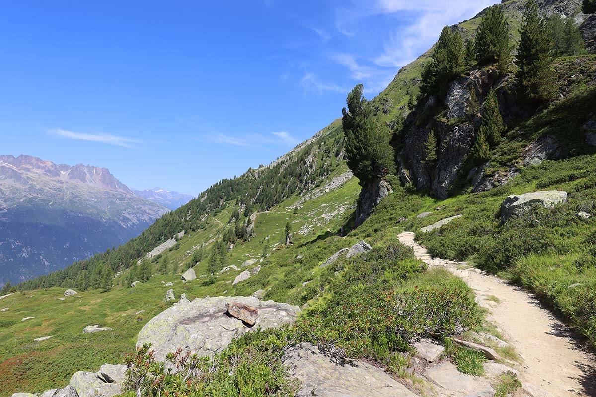
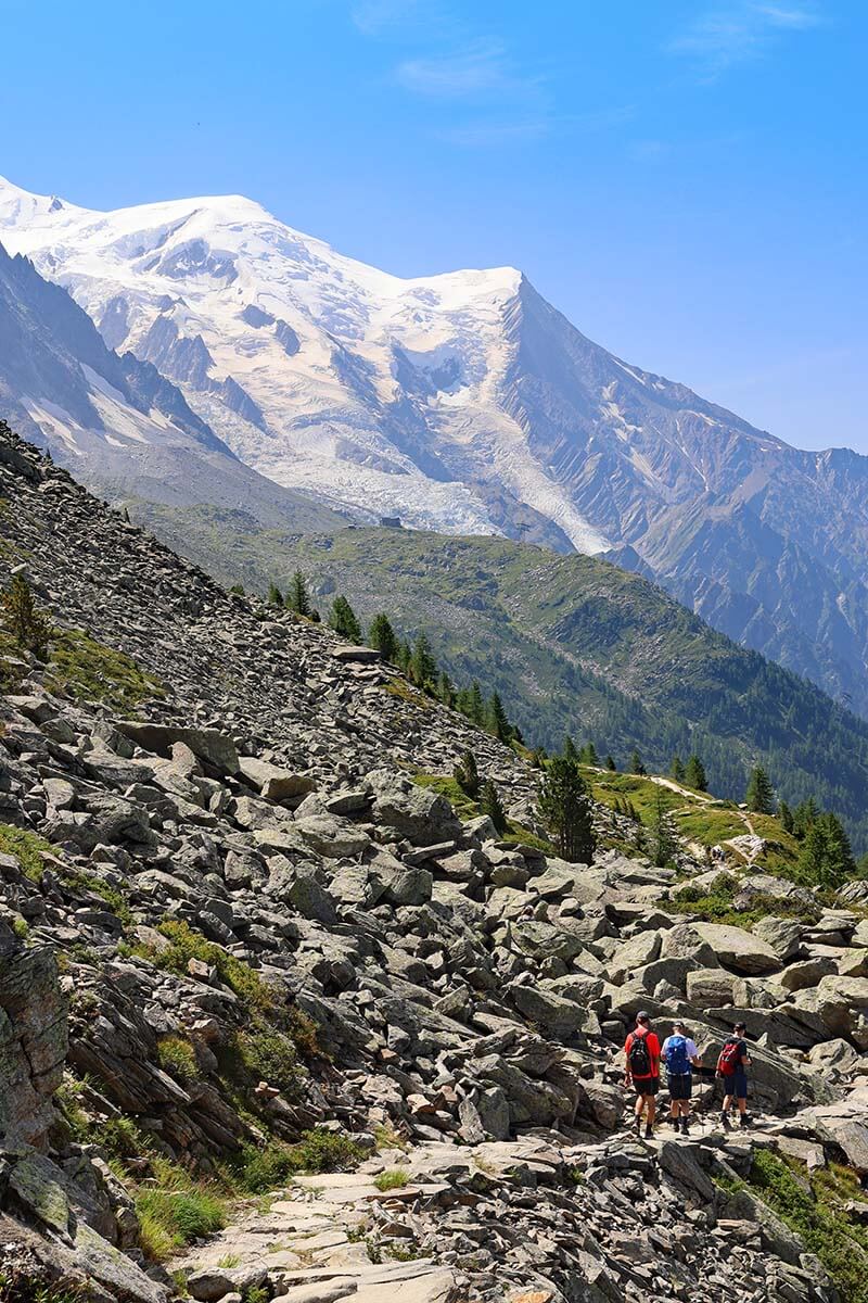
Once you leave Le Signal, you also leave the Mer de Glace Glacier and start walking toward the Mont Blanc. From here on, you will be looking at the Mont Blanc Massif pretty much all the time.
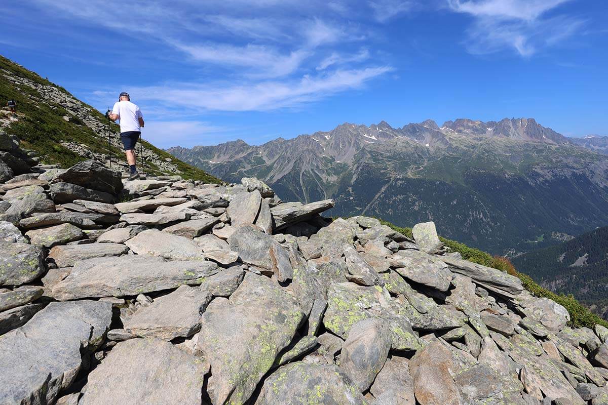
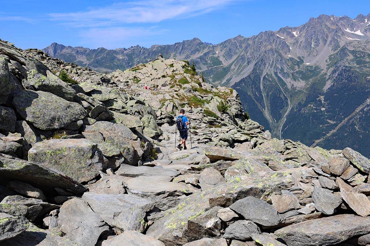
The trail follows a rather flat rocky path and is rather flat and easy – a welcome change after all the climbing.
At first, you go a bit downwards at a very relaxing pace, afterward it gets a bit steeper, and finally you zig-zag down on a rather steep trail until you reach the intersection with the original Grand Balcon Nord trail (the place where purple and red trails meet on our map above).
If for whatever reason you don’t want to do the entire Grand Balcon Nord trail, you could turn back toward Montevers station following the red trail from here. According to the signs, it takes about 45 minutes to get back to the train station from here. Just keep in mind that this part of the hike is more ‘delicate’ according to the official signs and maps.
Good to know: This part of the trail from Signal to the intersection takes about 30 minutes. It took us a few minutes longer because we stopped to pick some blueberries along the way. (We did this hike in late August which is the blueberry season and you will see people picking blueberries everywhere in the mountains around Chamonix).
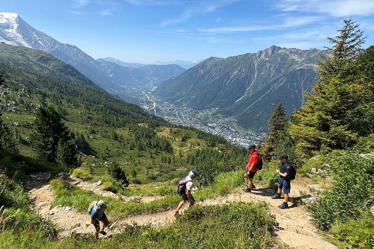
Grand Balcon Nord Route to Refuge du Plan de l’Aiguille du Midi
The signs at the intersection show that it takes 1h15 to reach the Refuge du Plan de l’Aiguille and 1h40 to reach Plan de l’Aiguille du Midi cable car station, the end point of this trail. This means that if you hike via Le Signal as we did, you are about halfway through the hike here.
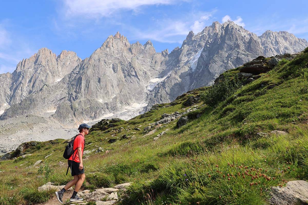
The trail from here on is rather simple, without too much elevation change, so you can relax and enjoy the views. Mont Blanc will be in front of you all the time so you have the most fantastic backdrop for all your pictures.
After a while, the trail starts going a bit uphill and you cross quite a few mountain streams. After a sharp corner, you will soon reach the mountain shelter Refuge du Plan de l’Aiguille. From here, it’s a 10-15 minute uphill walk to the cable car station at Plan de l’Aiguille du Midi.
Good to know: There are restaurants at both these places, so if you didn’t bring a picnic, you could have lunch here.

Plan de l’Aiguille du Midi
The Grand Balcon Nord hike ends at Plan de l’Aiguille du Midi, which is the middle cable car station between Chamonix and Aiguille du Midi mountain peak.
Here, you have several options. You could stay in this area a bit longer and hike to a small mountain lake, Lac Bleu (15-20 minutes hike one-way), go down to Chamonix by cable car (or hiking, but we do not recommend that), or take a cable car all the way to the top and visit Aiguille du Midi (recommended).
Good to know: If you plan to visit Aiguille du Midi after doing the Grand Balcon Hike, you can easily do this because the cable car only has to be reserved if you take it from Chamonix and not from the middle station. Just keep in mind that you will need at least 2 hours to visit Aiguille du Midi, likely even 3 hours including the cable car journey up and down.
Also, be sure to check the gondola schedule so that you have enough time for everything you want to do. We visited Mer de Glace, hiked the Grand Balcon Nord trail via Signal, and visited Aiguille du Midi on the same day and it all worked out great. But you really have to take one of the first trains from Chamonix to Montenvers in the morning to make this work, especially in the high season when it’s super busy everywhere.
Is Grand Balcon Nord Hike Worth It?
Since the Grand Balcon Nord hike starts and ends at places that can be easily reached without hiking, you may be wondering if it’s actually worth doing the entire hike. My answer is “YES! But…”.
When you travel as much as we do and have seen so many amazing destinations, it’s becoming more and more rare that we experience a real WOW moment. The views along the Grand Balcon Nord trail had this wow effect on us. It’s truly one of the most beautiful hikes we have ever done. So yes, it’s absolutely worth it!
If the weather is good, you enjoy hiking, and are in good shape to do a 2.5-3 hour hike, then yes, absolutely, go for it! The scenery is spectacular and you will see a lot more than at the cable car/train stations, especially if you hike via Le Signal.
That said, if the weather isn’t great, or if you don’t have the time to enjoy the hike at a relaxed pace, or if you are not a hiker and are worried that you may not be fit enough, then simply take more time to explore both ends of this trail without doing the entire hike. You will still see some phenomenal landscapes even if you don’t do the entire hike.
So, this is our guide to the Grand Balcon Nord trail. I hope that it gives you a good idea of what you can expect and helps you make the most out of your visit to Chamonix.
Have a great trip!
TIP: If you are also visiting Switzerland on this trip and are looking for some of the best hikes there as well, here are some of our absolute favorites:
- Best Hikes at Schynige Platte
- Oeschinensee Panorama Hike
- Stoos Ridge Hike
- Matterhorn Glacier Trail
- Bachalpsee Lake Hike
If you found this post helpful, don’t forget to bookmark it and share it with your friends. Are you on Pinterest? Pin this image!


Thank you so much for this! We are planning to go to Switzerland, but have never been to France and thought it would be fun to go over and do this hike. I don’t see a way to pin it on my Pinterest. Can you help me?
Hi Diane, normally you can save anything to Pinterest using your browser extension. If you don’t have it, here are links to the pins that you can easily save to your Pinterest account: Pin 1 and Pin 2.
Here is also a pin for the Chamonix guide if you want to save it too.
In addition, you may also want to check our Switzerland page with all our travel guides, favorite hikes, and practical information to help you plan.
Hope this helps. Have a wonderful trip!
Thank you so much!
I hiked this and also stayed at Héliopic in Chamonix. Unforgettable!!
That sounds unforgettable, Lisa! Chamonix is such a stunning place.
Holy cow! I am so thankful for the details you put into your hiking blogs! I used to think if your kids could do the hike then I could too, but now that they’re teenagers, it changes things!! lol!
I had a foot surgery get cancelled recently and was bummed because the new date will mess with our anniversary trip plans so my husband said, “well, plan a trip now!”
So… I have two weeks to get reservations and an itinerary for Chamonix, Zermatt and Grindelwald. (We live in US) We’ve been to all three but your blog is helping me pick new things to do at each place! Thank you so very much!! You are awesome! Maybe someday I’ll see you on the trails! Happy Adventures!
Hi Susan, Thank you for your kind words! I’m so glad to hear you’ve been using our blog to plan your trips (and it sounds like you’ve been with us for a while 😉). Indeed, these days, with our kids being in better shape than us, it’s less about whether they can handle a hike and more about whether we can keep up! 🙂 That said, this particular hike is definitely doable. The most challenging part for us was the detour to Signal Hill—but it was absolutely worth it.
Sorry to hear about your foot, but good on you for planning a last-minute trip anyway. Wishing you a fantastic time in the Alps!
P.S. We have tons of articles about Zermatt and a few about the Jungfrau Region (Grindelwald) on our blog. Unfortunately, just one or two about Chamonix. We have done a lot more in all of these places than I ever found the time to write about, so if you are looking for more ideas, I could probably overwhelm you with options – here are several suggestions:
If you are in Grindelwald for a few days, I highly recommend visiting Schynige Platte – it’s one of my favorites. If the weather isn’t great in the mountains, go to Interlaken and take a boat tour on one of the lakes.
If you are traveling by car between Zermatt and Grindelwald, take a car train, and you’ll pass Kandersteg. It’s well worth stopping for a night or two and visiting Oeschinensee – you can just go to the lake or do the panorama hike. On the Zermatt side, we also visited Leukerbad last year – while not as well known or as impressive as the top places, we enjoyed it, especially the hot pools to relax after all the sightseeing and hiking.
As for Chamonix, the most popular hike is actually the one to Lac Blanc, and there are several ways to get there. However, the lake is so popular that it almost feels like Disneyland when you get there. The shortest route is from the middle station of the Téléphérique de La Flégère cable car. It’s uphill but not too bad (thus, everyone is going there). We hiked down to Lac Blanc from the top station, L’Index, but that’s a bit more challenging Alpine trek.
We also really enjoyed a hike that takes you to the border of France and Switzerland – Tete de Balme (easy), with an optional detour to Croix de Fer (steep). You can reach it either from Vallorcine or from Le Tour (or start in one place and end in another), at the northern end of the Chamonix valley. It’s not as WOW as others, but a simple Alpine hike without the crowds.
Anyway, good luck with the planning and have a great trip!
PEEPS – Tell me any other blogger that pours out that much heart and soul into writing a response to a travel question!?
Thank you Jurga!!!!! A couple years ago I discovered Schynige Platte and Oeschinensee thanks to you!!! They were beautiful!!!! Some of the best adventures we’ve had!!!
I look forward to researching a few of your suggestions! You def take the feeling of being overwhelmed out of vacay planning – as I know you will steer us all straight!!
Happy trails to you… until we talk again!!
Thank you, Susan, and happy to help.
Have a wonderful trip!
We did this hike today and had a gorgeous day and magnificent views! Having all your feedback helps so much (like knowing the first 45 minutes is the hardest!) I’m
also happy to report we made it to the top of the Signal Forbes in 47 minutes! (Only two minutes off and I could be in a lot better shape!) We were able to get on the train at 9:20am, do the glacier cave and start the hike at 11:15. Thunderstorms were expected around 430 so the timing couldn’t have been better! There were a lot of people coming the opposite direction, and as I said my “Bonjour” I really just wished they would have read your travel blog so they could have had the awesome views too!!
Sounds like you had a great day, Susan! Thanks for your feedback — I’m so glad to hear everything went well and that you enjoyed those stunning views. And you even made it to Signal Forbes — well done, and totally worth it, right? Enjoy the rest of your trip!
So we need to book in advance the cable car from Plan de l’Aiguille du Midi on the way back to Chamonix, please?
Many thanks in advance
Hi Nina, if you take a cable car from Chamonix all the way to Aiguille du Midi, you have to make reservations for a specific time slot. You don’t need a reservation on the way back – not to the middle station and not from there down to the village.
The way it works is that you are given a time slot to go back down when you arrive at the top of Aiguille du Midi. When we visited, someone was sitting there and handing out paper ‘tickets’ with a time slot that you had to use to go back down to Plan de l’Aiguille. From there, you have to change to another cable car, and simply stand in line – there are no time slots for the last part of the journey to Chamonix.
You still need a ticket for all these sections, but timed reservations are only for those who go up from Chamonix.
Hope it’s clear. Enjoy your trip!
Many thanks indeed! Appreciate your help.
Thank you so much for your detailed, concise and helpful description!
Thank you for the kind feedback, Nina. Glad to help.
Hi, thanks for the detailed information. Just wanted to know the train and cable car prices if I just want to go from Chamonix to Mer de Glace and from Plan de aiguille to Chamonix.
Hi Moulindu, we had a multi-day pass so I don’t know how much individual tickets cost, but you can easily find all the up-to-date prices online.