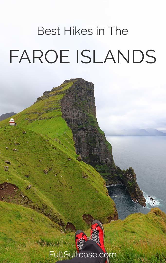
5 Absolute Best Hikes in The Faroe Islands (+Map & Tips)
This site contains affiliate links, which means that we may earn a small commission, at no cost to you, for qualifying purchases. It supports the work that goes into keeping this content free. Thanks for reading! More info: Privacy Policy.
There is no better way to explore a beautiful nature destination like the Faroe Islands than hiking. But what are the best hikes in the Faroe Islands?
There are so many hiking trails and walking routes in the Faroe Islands that it might be overwhelming to choose which ones are worth your time the most. Especially if you only have a couple of days and want to see the best that the Faroe Islands have to offer.
When planning our Faroe Islands itinerary, we came across a hiking brochure published by Visit Faroe Islands. It’s a beautiful booklet that you can find in pdf version online and also in visitor information centers across the country. It describes 23 hikes on 9 different islands and therefore gives you a lot of choices. Too many choices for an average tourist who only has a couple of days to explore the islands.
Therefore you still have to do some homework and research the best hikes in the Faroe Islands before your trip. One strange thing about this booklet is that it does not mention one of the very best hikes of the Faroes at all…
So to help you make the best of your trip, I made a selection of just 5 best hikes in the Faroe Islands that in our opinion are worth your time the most. If you have more time and want to do even more walking in the Faroe Islands, you can find a couple of other suggestions at the bottom of this post.
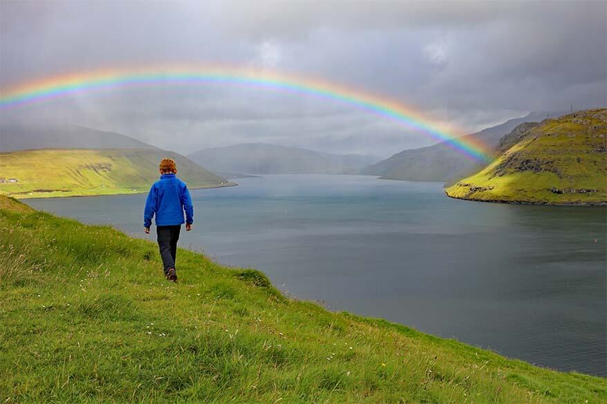
Just to make things clear from the start – walking in the Faroe Islands isn’t effortless. It’s often very muddy, the trails aren’t well marked, and you are dealing with the ever-changing weather conditions. The good news is that these hikes often lead to some of the most spectacular places and phenomenal landscapes. And once in a while, you might be rewarded by the most incredible rainbow…
Walking in the Faroe Islands is worth the effort (or at least the most beautiful hikes described in this post are). Also, apart from being slippery and muddy, the hikes mentioned in this post are not too difficult and are all doable for an average hiker; our kids age 7-9 managed just fine.
TIP: At the bottom of this post you can also find practical tips for walking in the Faroe Islands, as well as a map indicating the starting point for each of the hikes mentioned here. However, most hiking trails are really not well marked, so it’s best to either print the description from the hiking brochure or try to get a copy of it once you are in the Faroe Islands.
If you are looking for more practical information for your trip to the Faroe Islands, please check our first-timer’s guide to the Faroe Islands.
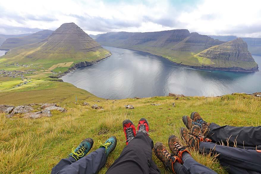
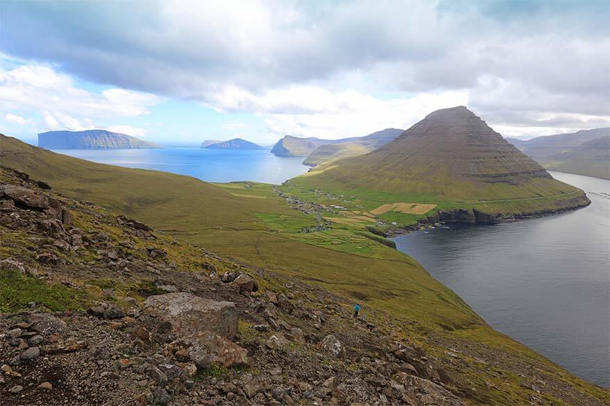
1. Villingardalsfjall and Enniberg (Viðoy island)
Villingardalsfjall hike starting in the old village Vidareidi (Viðareiði) is probably the most beautiful hike of the Faroe Islands. There are several options at the top of the mountain: you can go to the top of Villingardalsfjall (recommended) or climb to Enniberg (not recommended without a local guide).
If you are lucky to visit on a clear day, you will be rewarded with the most spectacular views over the northern islands Fugloy, Svinoy, Bordoy, Kunoy, and Kalsoy. But even if the weather is not as good, you can still enjoy nice views along the way to the top. This is however not the hike to attempt if it’s really misty.
With its 841 m (2759 ft) Villingardalsfjall is the fourth highest mountain of the Faroe Islands and you will feel it. This hike involves lots of climbing, pretty much all the way up. Despite this and the fact that Vidareidi is about as far from Torshavn as you can get to by car, it seems to be a popular hike.
Most people we met along the way didn’t make it all the way to the top and neither did we. We hiked up for about an hour and the view was amazing during the entire hike. I have no idea if the view is even better from the top than it is along the way, but the scenery along the first part of this hike was truly breathtaking. So impressive, in fact, that I put this hike as our absolute favorite in the Faroe Islands.
Practical information:
- Length and duration: 6km (3,7 miles), 3 – 4 hrs return. You can also choose to do just a part of the hike – it’s still worth it.
- Difficulty: moderate/difficult. We did this hike with three kids under 10 and while not entirely happy with the steep climb, they managed it quite alright. However, we didn’t get all the way to the top, so I cannot comment on the last piece that is said to be rocky with loose stones along the way.
- Starting point: North of Vidareidi village. See the map below for the exact location.
- Fee: One of our readers informed us that there is now a pretty high fee for this hike that can only be paid in cash. So be prepared for that.
- Guided tour: If you want to do this hike in its entirety, it’s best to do it with a local guide, because apparently, the last part of the hike is really not well indicated. Here you can book this hike with pick-up from Torshavn.
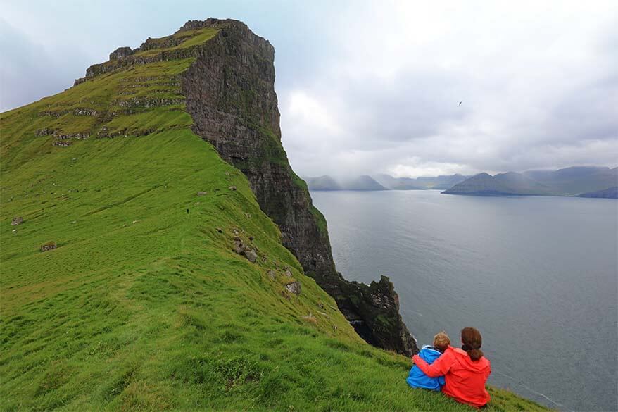
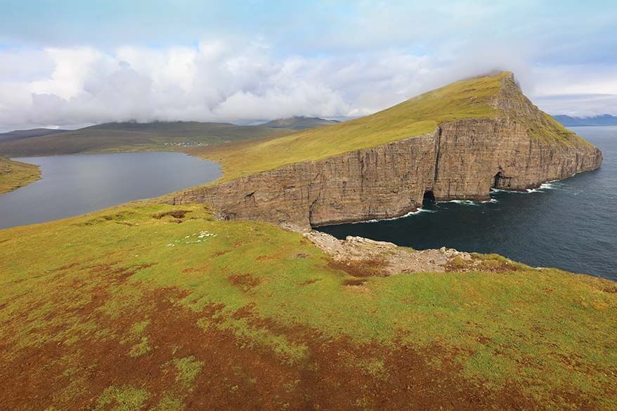
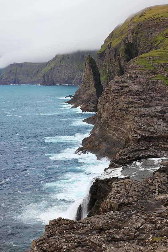
2. Kallur Lighthouse (Kalsoy Island)
The hike to Kallur lighthouse has to be the best-known secret of the Faroe Islands. For some strange reason it is not mentioned in the hiking brochure, yet everyone seems to know about it.
If it wasn’t for the limited space on the ferry to Kalsoy Island, this place would probably be overrun by tourists. Maybe that’s the reason why they rather not promote it too much…
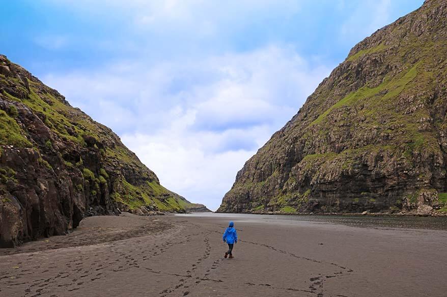
While the previous hike described above is all about the scenery along the way, it’s not really the case on Kalsoy Island. The walk to the Kallur lighthouse is muddy, you have to constantly navigate between the sheep droppings, and the landscape is a bit underwhelming…
But once you get to the lighthouse, the scenery takes your breath away. It’s the most beautiful coastline we have seen in the Faroe Islands!
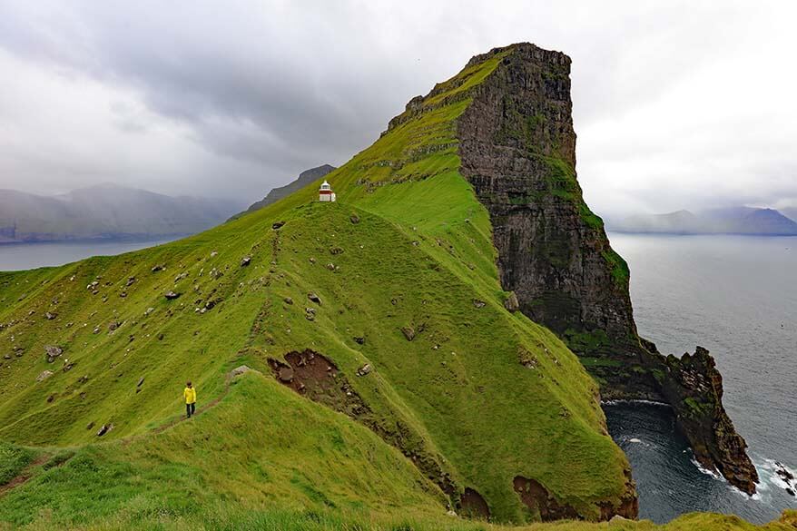
Make sure you spend some time here and explore the coastline in all possible directions. The best view is actually not at the lighthouse itself, but from a cliff right opposite of it. It looks a bit dangerous to get to and so most people never even try, but I found the path to be completely safe and it was so worth it.
In any case, you have to be really careful everywhere around the lighthouse as it’s really steep, slippery, and windy. So watch your step, take your time, and enjoy the views!
The biggest challenge of this hike is actually not the hike itself; it’s quite easy, short, and rewarding. The challenge is to get on the tiny ferry that brings you to Kalsoy Island.
There are just a few boats running from Klaksvik on Borðoy island to Syðradalur on Kalsoy island. The ferry can take 17 small cars at best. In high season they simply don’t have enough capacity to take all the tourists who want to visit Kalsoy. So you either have to go very early in the morning, late in the afternoon, or arrive at least 1 hour before the ferry. Recently, in the summer, it was also possible to reserve this ferry in advance, so you may want to check the official website to see what the situation is at the moment.
Practical information:
- Length and duration: I’m not sure how long the hike is, my guess it’s about 4 km (2,5 miles)round trip. It took us 35 minutes to get there and a bit less to come back.
- Difficulty: easy/ moderate. The biggest challenge is the first steeper section that can be very muddy and slippery.
- Ferry from Klaksvik to Kalsoy Island: Here you can find the ferry schedule. In high season, make sure you are at the harbor at least an hour in advance.
- Starting point: Parking lot in Trøllanes village. See the map below for the exact location.
- Fee: There is now a 200 DKK fee (for foreigners only?) to access the hike to Kallur Lighthouse. You are also only allowed to hike here during the day.
- Guided tour: If you rather visit Kalsoy Island with a local guide, it’s possible to book a guided day tour that visits not just Kalsoy Island, Kallur Lighthouse, but also the Northern Islands. It’s a great way to see this whole area in one day and not have to worry about the practicalities.
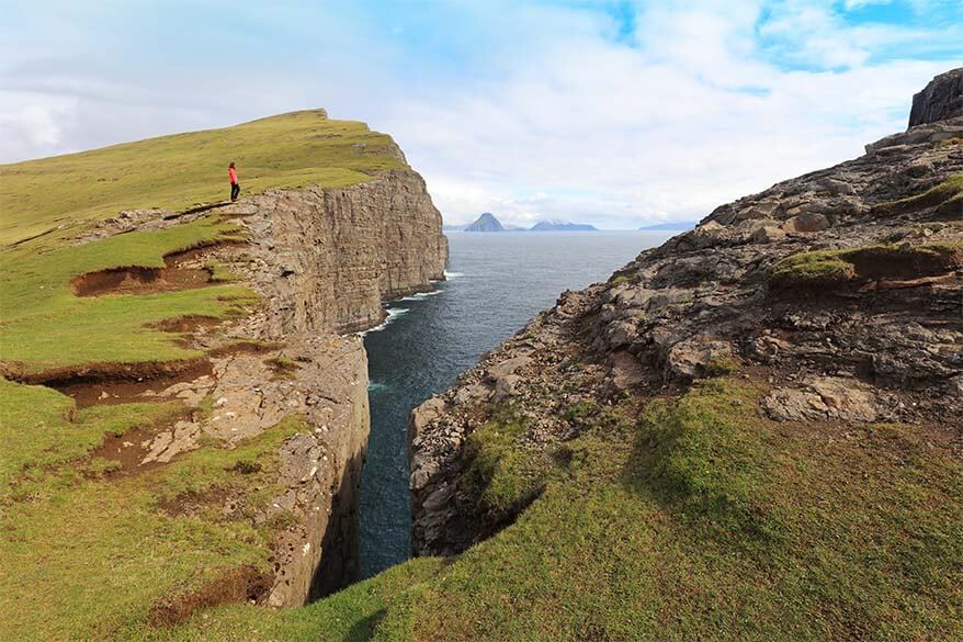
3. Trælanípa – Bøsdalafossur (Vagar island)
The hike from Miðvágur to Bøsdalafossur waterfall and Trælanípa mountain is without any doubt the most popular hike in the Faroe Islands. It’s close to the main road between the airport and the capital city Torshavn. Furthermore, it’s an easy walk and is very rewarding. It seems that if people do just one hike in the Faroe Islands, it’s this one.
Bøsdalafossur – Trælanípa hike follows the Sørvágsvatn lake (also called Leitisvatn or Vatnið – why make things easy, right?). It’s the largest lake in the Faroe Islands and you’ll find many birds in this area during summertime.
Contrary to all the other hikes in the Faroes, the main trail is quite well indicated and easy to follow. It’s also quite well maintained and not even remotely as muddy as all the other places we visited. You’ll have to jump over a few minor streams, but nothing to worry about. Kids and older people will manage this trail just fine. The only challenge is the climb up the Traelnipa mountain at the end of the walk.
Trælanípa mountain is the last hill on your left hand side almost at the end of the trail. It’s not very high and in just a few minutes you can reach the top. From here you can see many nearby islands, the stunning coastline, and of course the famous most-photographed view over the Sørvágsvatn lake. Just be careful here – it’s really steep, slippery, and you don’t want to get too close to the edge.
After Trælanípa you can choose to go back to the car parking, or turn left and continue to the end of the lake. The trail isn’t indicated, but if you just follow the lake, you can’t really go wrong. At the end of the lake you’ll find a beautiful waterfall, Bøsdalafossur, where the water of the lake thunders down into the Atlantic Ocean.
For some reason, very few people seem to make it to the end of the walk, but it’s a fascinating sight, so don’t miss it. You can even cross the river (there are stepping stones) and walk up to a gorge with a view over the Geituskorardrangur cliff.
The trail back, as it is indicated in the hiking brochure, follows the lower path along the lake and ends up in a different part of the village than where it starts. Most people (us included), however, take the same path back to the car parking.
Practical information:
- Length and duration: 6-8 km, 2-3 hrs (starting and ending at the parking lot). The exact distance and time will depend on the exact route you choose and your starting/ ending point. Hiking brochure says it’s a 10km walk, but that’s not the case if you start/ end at the car parking.
- Difficulty: easy/ moderate. The biggest challenge might be a short climb at the end of the hike.
- Starting point: Small parking lot in Midvagur. Coming from Sandvagur, turn left on the first street after you pass the church and just follow the signs. It’s well indicated from the main road.
- Fee: Recently, the owner of the land started charging an environmental/ maintenance fee to people who want to do this hike. The fee has fluctuated a bit in the beginning, but he seems to have settled at 200DKK (+-30USD) per person. It seems that guided tours are being pushed in order to protect the fragile environment and to make sure that people stay on paths…
- Guided tour: If interested, here you can book a guided Traelnipa hike – this tour is a good choice because it includes much more than just Traelnipa hike. It also brings you to all the other best places on Vágar island, such as Gásadalur, Múlafossur, and Bøur. This tour will pick you up anywhere on Vagar island, but not in Torshavn. If you are interested in photography as well as hiking, you may want to consider this tour of Vagar Island. The itinerary of both tours is very similar.
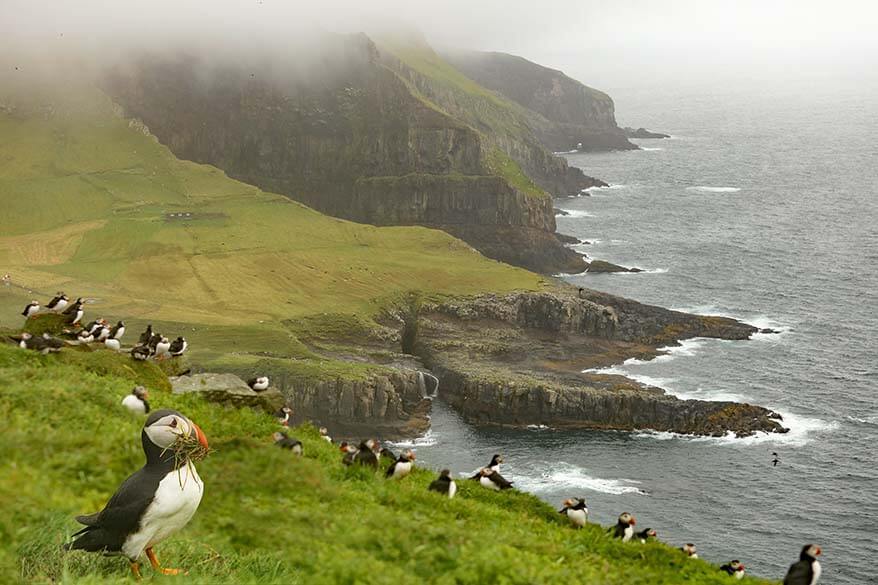
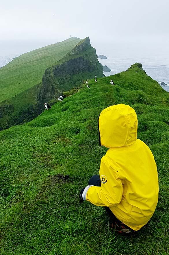
4. Mykinesholmur (Mykines island)
Mykines island is probably one of the most special places you will ever visit. Not just in the Faroe Islands. Ever.
One of the best things to do in Mykines is hiking Mykinesholmur all the way to Mykines lighthouse. The scenery here is second to none and if you come on a sunny day, it’s as beautiful as it gets.
Hiking is not the main reason why Mykines is so popular with tourists. This island with its sheer cliffs is home to a big colony of puffins that come to nest here every summer. On top of that, it’s one of the very few places where you can expect to see gannets in the wild.
There are, however, many obstacles to visiting Mykines, seeing the puffins, and doing this stunning hike. Find out!
First, the island can only be reached by helicopter or by a small boat (see practical information below). Second, the hike to the lighthouse is quite steep and muddy and it often gets closed if it becomes too dangerous. Third, puffins are of course wild birds and may not always be there. On top of that, there are talks about limiting tourist access to the puffin nesting area. Increasing tourist numbers mean more and more damage to the already fragile landscape…
Even if the weather isn’t cooperating, even if the hike is closed and access to the puffin nesting area is limited, Mykines is still a place worth visiting. It’s probably even more special to experience it on a windy rainy day as it makes you wonder how life should be on this island in the middle of the winter…
We visited Mykines on such a miserable wet day. The hike to the lighthouse was closed, so we didn’t get to experience it to the fullest. But we saw hundreds, thousands of puffins. We saw incredible landscapes and a tiny remote village in the middle of the harsh Atlantic Ocean. And it was still worth a trip.
Practical information:
- Length and duration: 7-8 km, 2,5-3 hrs.
- Difficulty: moderate. The biggest challenge is the slippery mud. Also the steep climb in the beginning of the hike, followed by a steep descent to the bridge, and then the climb back up.
- Ferry to Mykines: Ferry only operates weather-permitting, from the 1st of May till the end of August. I’m not sure if you can get here by boat outside this season, so it’s best to call the company operating the ferry and inquire about the possibilities. This is the only ferry in the Faroe Islands that has to be booked in advance (and it often sells out). Here you can find the schedule and book the ferry.
- Shuttle boat to Mykines. This is a rather new offer and is by far the fastest and easiest way to get to Mykines Island. The boat runs in the summer season, from June to early September. You can find more information and book this boat here (be sure to reserve in advance!).
- Helicopter to Mykines: Helicopters on the Faroe Islands are actually meant to help local people, but the rides are so cheap that it has become a popular thing to do for tourists. The helicopter to Mykines is probably the most sought-after and since this summer you can only book one week before departure (here is the booking website). It only has 12 seats and gets fully booked in no time. Please keep in mind that they only fly a few days a week (see the schedule here) and you can never take it both ways on the same day, so you still need to get the boat to come back or be prepared to stay on Mykines for a few days. We tried to book the helicopter for our visit to Mykines and it was fully booked at 7 AM on the day the bookings were possible. On top of that, by then there were no places left on the evening boat. So even if we could have booked the flight, there was no way to come back. It turned out so much easier to just book the boat both ways for another day. This is what I recommend for you too, or you risk not being able to visit at all.
- Hiking fee: You have to pay to go hiking on Mykines Island. You can now simply pay upon arrival on the island.
- Starting point: Before you reach the village, there will be a sign to Mykinesholmur on your left side.
- Guided tour: If you want to visit Mykines with a local, here you can find the most popular tour options.
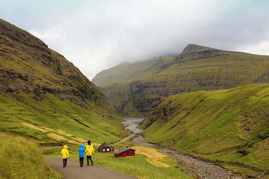
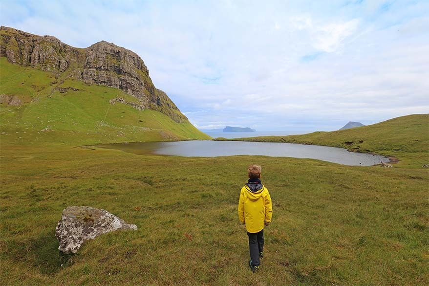
5. Saksun – út á Lónna (Streymoy island)
The most popular hike near Saksun is actually not this hike, but Saksun – Tjornuvik hike that is indicated in the hiking brochure.
However, if you are not up for a difficult long hike climbing a mountain between the two villages (and back), a beautiful hike called út á Lónna is not just easier, but probably a much better option to explore the majestic landscapes near Saksun. After all, how many visitors actually have 5-6 hours to hike between the two villages…
TIP: If you want to do the Saksun Tjornuvik hike, it’s best to do it with a guide because they’ll arrange for the transport to come back to the starting point. You can book a guided hike here. In that case, it will only take about 3 hours.
The út á Lónna hike is easy, flat, and suitable for all ages. It also takes much less time – count 1-2 hours, depending on how far you choose to walk. The scenery here is simply unbelievable and hardly any tourists seem to come to this part of the popular Saksun village.
We discovered this hike by coincidence, on our first day in the Faroe Islands and it was love at first sight. As we left the village and walked along the fjord out to the black sand beach by the ocean, we couldn’t believe how beautiful and tranquil this place was. It’s one of those experiences that makes you feel small and humble compared to the majestic nature that surrounds you.
Practical information:
- Length and duration: 6 km, 1-2 hrs. You can make this walk as long or as short as you want to.
- Difficulty: Easy. The biggest challenge is the tide. You should not walk here in high tide, or in any case not till the end of the trail.
- Starting point: The first parking lot on your left hand side when you enter Saksun village, before you cross the bridge. Walk west towards the fjord and you’ll soon find a sign with the map of the walk.
- Fee: According to our readers, there is now a fee to enter the beach at Saksun. It’s about 75 DKK (+-10 EUR).
Other Nice Hikes in The Faroe Islands
As mentioned before, the five hikes selected above, were our personal favorite hikes in the Faroe Islands. Those are the hikes that we recommend the most. However, if you have more time and love to do more walking in the Faroe Islands, there are many more hikes to consider.
Here are a few other beautiful hikes that we recommend in the Faroe Islands:
- Hvannhagi hike (Suduroy island). Probably the most off the beaten path hike we did in the Faroe Islands. Little to no indications make this hike difficult to navigate, but a spectacular view at the end makes it all worth it. If you are visiting Suduroy island and have 2-3 hours to spare, check it out!
- Nólsoy Borðan (Nosloy island). Long walk to the lighthouse at the southern part of Nolsoy island is, in our opinion, not really worth the time that it takes (13-14km, 5hrs). However, Nolsoy island is definitely worth a short visit and we recommend doing the first part of this hike. The best views are in the beginning, just as you climb the hill.
- Slættaratindur (Eysturoy island). Slættaratindur is the highest mountain in the Faroe Islands. If you are lucky to visit this area without the mist covering the view, this is one of the most beautiful hikes you could consider as well. Count 2-3 hours. Faroe Islands’ highest mountain can also be visited with a local guide. Here you can book a Slættaratindur guided tour that also visits Saksun, Tjørnuvík, and lots of other amazing places in the Faroes in one day.
TIP: All these recommendations for walking in the Faroe Islands are based on our personal experience and conditions at the time of our visit. For more practical information for these and other hikes, please refer to the hiking brochure of Visit Faroe Islands.
Best Hikes of The Faroe Islands on The Map
On this map, I indicated the starting points for each of the Best hikes of the Faroe islands described in this post.
Don’t forget that some of these hikes can only be accessed by taking a ferry, so make sure to check the schedule and prepare in advance.
How to use this map: Use your computer mouse (or fingers) to zoom in or out. Click on the icons to get more information about each place. Click the arrow on the top left corner for the index. Click the star next to the map’s title to add it to your Google Maps account. To view the saved map on your smartphone or PC, open Google Maps, click the menu and go to ‘Your Places’/’Maps’. If you want to print the map or see it in a bigger window, click on ‘View larger map’ in the top right corner.
Practical Tips for Hiking in the Faroe Islands
- Dress for the ever-changing weather. Layers, warm clothes, waterproof jacket, rain pants, cap, and gloves are a must in any season. Dressing for the Faroe Islands is actually pretty much the same as what I recommend packing for Iceland.
- Sturdy waterproof hiking shoes with good grip are a must too. We always wear hiking shoes with Vibram soles. Even then, you still have to be very cautious as hiking in the Faroe Islands is the most slippery I have ever experienced.
- I also highly recommend taking hiking poles with you when planning to do any walking in the Faroe Islands. We really missed them.
- Always pack a picnic and drinking water. A thermos with your favorite hot drink might be nice to have.
- Make sure you have a description of the hike with you. According to the brochure, tourist information might help you with a digital copy of the hiking maps as well.
- Don’t start the hike if it’s misty. It’s really easy to get lost; and some areas with steep cliffs are just too dangerous to take a risk.
- Some of these hikes are also possible in winter. I don’t have personal experience with that, but if you want to be on the safe side, make sure to ask locals about the conditions. Here you can find organized winter tours.
- If you want to take it really easy and not have to worry about the practical side of planning these hikes, you can always join a guided hike with a local guide. I indicated the best options under the practical information section under each hike. In addition, on this local website, you can find all the guided tours that are available on the Faroe Islands.
So, these are the most beautiful hikes in the Faroe Islands that are worth your time the most. There are many other hiking trails in the Faroe Islands, so if you have more time, I encourage you to explore more. But if you are only visiting the Faroe Islands for a few days, these 5 hikes are truly the best ones.
More tips for visiting the Faroe Islands:
- Practical info: First-timer’s Guide to the Faroe Islands – Practical Tips for Your Visit
- Where to stay: Faroe Islands Hotels & Accommodation Guide
- Itinerary: Faroe Islands Itinerary
If you found this post helpful, don’t forget to bookmark it and share it with your friends. Are you on Pinterest? Pin this image!

Hello,
Thank you for this article! I noticed that the path to the lighthouse on Mykineshólmur is closed in 2024 due to a landslide. Would you still recommend the Hike #4 Mykines island even though you can’t go to the lighthouse?
Thanks in advance for any insights!
Hi Marlene, yes, it’s absolutely worth visiting Mykines either way. There are so many puffins (in summer season) and the scenery is stunning.
Enjoy your trip!
Thanks for this list! As of 2023, there is now also a charge to hike to Kallur Lighthouse.
Why I’m not surprised… Thanks for letting us know, Wendy!
Hi Jurga,
I do have a plans to explore Faroe islands next year. I would like to get one advice – is it possible to travel by foot from one destination to another, staying at a diferent local hotels/hostels/guest houses all the time?
I just come to this idea, that it shouldn’t be a problem to explore the Islands by foot, since I make about 120-170 km by foot each week (20-30 km per day when purely walking). If exploring by foot is not a good idea, what is the best option?- to rent a car, or buses are also as an option?
Thank You
Ramunas
Hi Ramunas, I really wouldn’t know. We traveled by car and I can’t imagine trekking through all the islands. I guess it could be possible here and there, but keep in mind that the roads are narrow, it’s quite hilly, and it rains a lot. Plus, there are lots of tunnels, etc. so you wouldn’t be able to walk everywhere.
There is public transport available, but you’d have to research that yourself.
One more tip – you can’t just show up somewhere and hope to find accommodation. The facilities are quite limited in many places and whatever is available, is often fully booked in the summer.
So all in all, I’d say rent a car and prebook your accommodations – it’s so much simpler and you’ll be able to see and do so much more.
Good luck with the planning!
I must thank you. On the third day, we wanted an easier hike. At 6am this blog came to mind. I saved the link pre-covid, back when we started planning.
The Saksun ut a Lonna hike was fabulous. We came near low tide. The walk across black sand between the mountains out to the sea was majestic. Jurga’s description of the hike is spot on. It’s was a fjord until a 1960 storm brought the sand in. It’s cool to walk the length of fjord (until you reach water) with majestic cliffs and waterfalls all around you. Definitely time the walk around low tide. You can walk farther out if the window is 3 hrs. before, during, or 3hrs. after low tide.
When you come up to Saksun pull into the first parking lot, before the bridge. You walk down into the fjord onto the black sand. You need a credit card to get through the turnstile. Only 75dk. The drive to Saksun on the one lane road was fun. It was a great last minute decision.
Thank you for your kind feedback, Rick.
Glad to hear you enjoyed the hike. We really liked it too – the scenery is amazing and it’s a rather simple easy walk that doesn’t require much effort.
And thanks for the up-to-date practical info – I’m sure it will be helpful to other readers.
Happy travels!
Dear Jurga.
Thanks for such a wonderful blog post. We are traveling in June this year, and I was planning to book the hikes in advance. But I can’t seem to do so online.
1. Do you believe it’s not a limited number of people a day for the hikes and if I should be fine to book on-site rather than online?
2. Is a guided tour necessary (some blogs I saw mentioned it was), or all hikes should be okay without needing a guide?
Thank you much, again.
Hi Charanjeet, I just tried and you can definitely book tours for June on the Guide to Faroe Islands website. This might depend on the number of people, however, as some tours might not run if it’s just 1-2 people.
And no, for most hikes, you don’t need a guided tour, as long as you have the transport to get there and back. We did all the hikes on our own, but we did have a car. Without a car, it would be very difficult to go on your own. Also, if you want to do any of the one-way hikes (such as Saksun – Tjornuvik), there, it’s also easier to go with a tour so that you don’t have to walk back the same way.
For Mykines, you have to book a boat and pay a fee either way, so there, you can just as well opt for a tour like this.
Also, for Kolsoy island, you have to plan well in order to get there and back (even if you have a car – since ferries fill up very quickly). So there also, you may want to simply book a guided hike. But it’s not a must.
Hope this helps.
We have a car, so for the Saksun> Tjornuvik hike, how about we take the mountain pass over and then the ut a Lonna path back? Would that make sense? Or can we bus or hitchhike back to Saksun? Any advice? Thanks
Hi Rick, as mentioned in the article, we didn’t do the Saksun-Tjornuvik hike and just visited the two villages by car. For the exact same reason – arranging transportation back wasn’t straightforward and we didn’t feel like hiking 5-6 hours with kids. It was also VERY windy when we visited and the hike we did by the sea as described in the article was much easier and it was warmer down below.
That being said, from everything I read, it’s a very nice hike, but there’s no easy way to get back to your car unless you walk back the same way or take this tour, in which case it’s just a one-way hike and they take care of transportation.
I’m not aware of any alternative ways to do (part) of the hike and the út á Lónna hike is on the other side of the water and I don’t think you can even get there from the Saksun-Tjornuvik hike. I also don’t think there’s a bus between these two villages…
You could also just do part of the hike from Saksun, then come back, potentially do the út á Lónna hike, and then drive to Tjornuvik and visit the village and the beach there. It’s not the same as doing the entire hike, but you’ll get to see some of the best scenery this way. Also, the road to Tjornuvik is extremely scenic and well worth doing.
Have a great trip!
Hi Jurga,
First of all, thank you for writing such a detailed blog on trekking in Faroe islands. We just came back from Faroe and did all the hikes based on your blog 🙂
Just wanted to highlight that it seems from this year, their are entrance charges which trekkers have to pay at few of the hiking spots.
In addition to the Traelnipa hike (#3 option, which we did and paid 200 DKK pp) and Sakun (option 5, paid 75 dkk pp), we also saw entrance fee of DKK 200 for Villingardalsfjall hike (#1 option), sadly here you can only pay in cash and their are no atm around this place/town and we didn’t had 800 dkk to pay for 4 people. We ended up doing Slættaratindur hike, which is still free.
Wanted to highlight this fact for the benefit of other readers 🙂 so that they can plan better.
Again, thank you so much for taking the trouble of writing such a detailed blog.
Oh wow, thank you for letting me know, Siddharth. I’ll see if I can include this information in my post – it will certainly be useful to others.
I can’t believe they are now charging so much for hiking in the Faroe Islands. I can’t think of many places in the world where we would have had to pay to hike, and also that much money… In the European Alps, you pay for trains or gondolas in the mountains, but never to hike. In the US, you can get a yearly National Park Pass for the whole family for 80 USD and hike as much as you want in any National Park for 365 days… In Norway, in Iceland, in Greenland, all the natural wonders are completely free…
It’s really a pity that the Faroe Islands decided to take this course, I find. There are better ways to keep tourist numbers under control and get money for conservation than charging people 30 USD for a possibility to hike… Sad.
Anyway, I’m happy to hear that you had a great trip and that our blog helped you make the most of it. Hope you’ll come back to read about other destinations on our blog as you plan your future trips! If you liked the Faroe Islands, I really recommend Iceland and Greenland – both even more impressive.
Thank you for all the info, your blog has the most complete guide on Faroe Island that I’ve seen!
I’m not used to hiking and I’m definitely not a fitness guy, so would you say that hikes 2, 3 and 5 are doable even for someone like me (or the elderly)? I know that’s a tough question, but I enjoy walking – just not used to it. Thanks in advance!
Hi Diego, the easiest ‘hike’ from this list is #5 Saksun – út á Lónna – but only walk there at low tide. Then – #3 (Trælanípa – Bøsdalafossur ) which is as good as flat, except for the last part if you choose to walk up the hill. #2 (Kallur lighthouse) is a bit more uphill, but also quite doable for everyone I think.
Mykines Island is amazing, so I would say go there even if you don’t hike. Maybe just walk a small part of the trail (#4) – if you go in summer, you can see thousands of puffins.
If you aren’t used to hiking, I would recommend taking good walking sticks (we have foldable carbon poles from Black Diamond) with you – hiking can get really muddy in the Faroe Islands so good hiking boots and hiking poles are advisable.
Thanks for the great detail! Greatly appreciated!
Hi- thanks for the great recommendations! Just wanted to note that the #3 Traelnipa hike is still a great hike (did it today) but as of April 2019 there now is a steep 200krr per person entrance fee to finance facilities and significant trail improvements/maintenance.
Oh WOW, Chris. Thanks for sharing this. I just checked and many people are saying the same thing – the land owner is now charging outrageous fees to people who want to do this hike.
I can understand that maintaining the paths costs money, but 200DKK, that’s like 30 USD! Per person. Can’t believe it. It definitely feels like it’s quite overpriced, but then most things in the Faroe Islands aren’t cheap…
Anyway, thanks a lot for sharing this. Enjoy the rest of the trip!